|
|
|
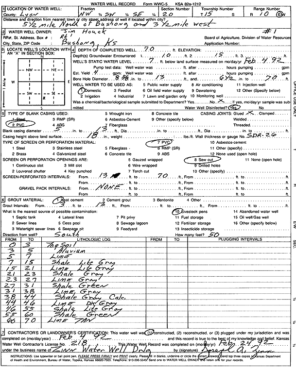
Specific Water Well Detail |
|
|
| Location Info | |||
| Owner: Houck, Jim | Status: Constructed | ||
| Location: T15S, R10E, Sec. 20, NW SW SE | County: Lyon | ||
| Directions: from Bushong: 5.5 mi N, 3.5 mi W | |||
| Latitude: 38.7272455 | Longitude: -96.3243282 | Datum NAD 27 | |
| Latitude: 38.7272513 | Longitude: -96.3246046 | Datum NAD 83 | |
| Longitude and latitude calculated by Survey from township-range-section-quarter calls. Only good to within the quarter call accuracy. | |||
| View well on interactive map | |||
| General Info | ||
| Well Depth: 70 ft. | Elevation: ft. | |
| Static Water Level: 7 ft. | Est. Yield: 4 gpm. | |
| Comp. Date: 04-Feb-1992 | Well Use: Domestic | |
| DWR Applic. #: | Other ID: Well 1 | |
| Driller Info | ||
| Driller: Zinn Water Well Drlg. | License #: 218 | |
| Scanned Form | View scan |
|
Chemical Sample Submitted?: No
Water Well disinfected?: | ||
| Ground water encountered: 10 ft. , 15 ft. , 0 ft. | ||
| Pump test data: Well water was 0 ft after 0 hours pumping 0 gpm | ||
| Casing Info | ||
| Casing Type: PVC
Casing Joints: |
Diam: 5 in. to 13 ft
Diam: 0 in. to 0 ft Diam: 0 in. to 0 ft | |
| Casing height above land surface: in
Casing Weight: lbs/ft Wall thickness or gauge no.: | ||
| Screen and Perforation Info | ||
| Screen Type: PVC | Screen Openings: Saw cut | |
| Screen-perforated intervals | From: 13 ft to 70 ft
From: 0 ft to 0 ft From: 0 ft to 0 ft | |
| Gravel pack intervals | From: ft to ft | |
| Grout Info | ||
| Grout used: Neat cement | From: 3 to 13 ft
From: 0 to 0 ft From: 0 to 0 ft | |
| Source of Possible Contamination | ||
| Source: Livestock pens | ||
| Direction from well: | Distance: 0 ft | |
| Lithologic Log
(Log data entered by KGS.) | ||
| From: 0 ft. to 3 ft. | top soil | |
| From: 3 ft. to 5 ft. | alluvium | |
| From: 5 ft. to 7 ft. | limestone | |
| From: 7 ft. to 15 ft. | shale, light gray | |
| From: 15 ft. to 21 ft. | limestone, light gray | |
| From: 21 ft. to 23 ft. | shale, gray | |
| From: 23 ft. to 27 ft. | limestone, gray | |
| From: 27 ft. to 31 ft. | shale, green | |
| From: 31 ft. to 38 ft. | limestone, gray | |
| From: 38 ft. to 44 ft. | shale, gray, calc. | |
| From: 44 ft. to 46 ft. | limestone, dark gray | |
| From: 46 ft. to 55 ft. | shale, light gray | |
| From: 55 ft. to 60 ft. | shale, green | |
| From: 60 ft. to 70 ft. | limestone, tan | |