|
|
|
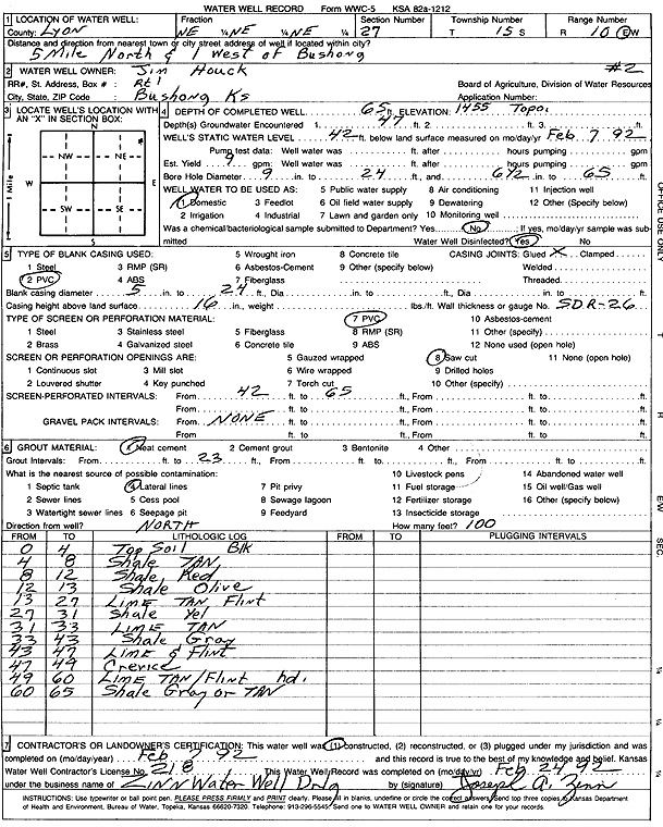
Specific Water Well Detail |
|
|
| Location Info | |||
| Owner: Houck, Jim | Status: Constructed | ||
| Location: T15S, R10E, Sec. 27, NE NE NE | County: Lyon | ||
| Directions: from Bushong: 5 mi N, 1 mi W | |||
| Latitude: 38.7234911 | Longitude: -96.2806056 | Datum NAD 27 | |
| Latitude: 38.7234971 | Longitude: -96.2808809 | Datum NAD 83 | |
| Longitude and latitude calculated by Survey from township-range-section-quarter calls. Only good to within the quarter call accuracy. | |||
| View well on interactive map | |||
| General Info | ||
| Well Depth: 65 ft. | Elevation: 1455 ft. | |
| Static Water Level: 42 ft. | Est. Yield: 9 gpm. | |
| Comp. Date: 07-Feb-1992 | Well Use: Domestic | |
| DWR Applic. #: | Other ID: Well 2 | |
| Driller Info | ||
| Driller: Zinn Water Well Drlg. | License #: 218 | |
| Scanned Form | View scan |
|
Chemical Sample Submitted?: No
Water Well disinfected?: | ||
| Ground water encountered: 47 ft. , 0 ft. , 0 ft. | ||
| Pump test data: Well water was 0 ft after 0 hours pumping 0 gpm | ||
| Casing Info | ||
| Casing Type: PVC
Casing Joints: |
Diam: 5 in. to 24 ft
Diam: 0 in. to 0 ft Diam: 0 in. to 0 ft | |
| Casing height above land surface: in
Casing Weight: lbs/ft Wall thickness or gauge no.: | ||
| Screen and Perforation Info | ||
| Screen Type: PVC | Screen Openings: Saw cut | |
| Screen-perforated intervals | From: 42 ft to 65 ft
From: 0 ft to 0 ft From: 0 ft to 0 ft | |
| Gravel pack intervals | From: ft to ft | |
| Grout Info | ||
| Grout used: Neat cement | From: 3 to 23 ft
From: 0 to 0 ft From: 0 to 0 ft | |
| Source of Possible Contamination | ||
| Source: Lateral lines | ||
| Direction from well: | Distance: 0 ft | |
| Lithologic Log
(Log data entered by KGS.) | ||
| From: 0 ft. to 4 ft. | top soil | |
| From: 4 ft. to 8 ft. | shale, tan | |
| From: 8 ft. to 12 ft. | shale, red | |
| From: 12 ft. to 13 ft. | shale, olive | |
| From: 13 ft. to 27 ft. | limestone, tan, with flint | |
| From: 27 ft. to 31 ft. | shale, yellow | |
| From: 31 ft. to 33 ft. | limestone, tan | |
| From: 33 ft. to 43 ft. | shale, gray | |
| From: 43 ft. to 47 ft. | limestone and flint | |
| From: 47 ft. to 49 ft. | crevice | |
| From: 49 ft. to 60 ft. | limestone, tan, with flint, hard | |
| From: 60 ft. to 65 ft. | shale, gray or tan | |