|
|
|
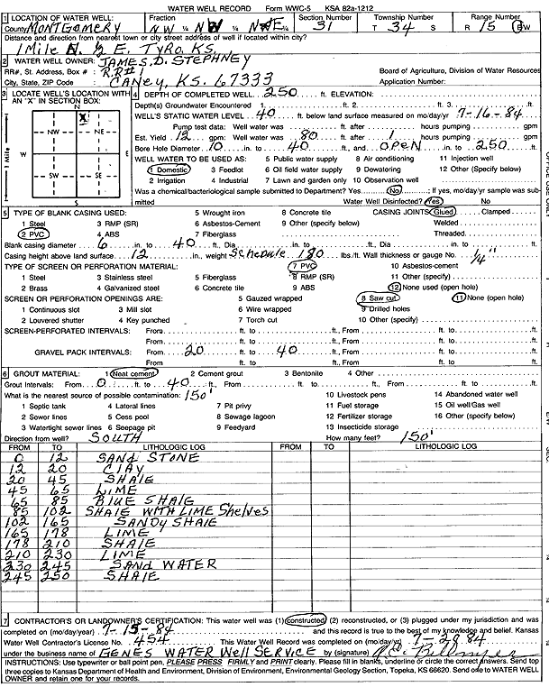
Specific Water Well Detail |
|
|
| Location Info | |||
| Owner: Stephney, James D. | Status: Constructed | ||
| Location: T34S, R15E, Sec. 31, NW NW NE | County: Montgomery | ||
| Directions: from Tyro: 1 mi N, .5 mi E | |||
| Latitude: 37.0506814 | Longitude: -95.8089642 | Datum NAD 27 | |
| Latitude: 37.0507566 | Longitude: -95.8092217 | Datum NAD 83 | |
| Longitude and latitude calculated by Survey from township-range-section-quarter calls. Only good to within the quarter call accuracy. | |||
| View well on interactive map | |||
| General Info | ||
| Well Depth: 250 ft. | Elevation: ft. | |
| Static Water Level: 40 ft. | Est. Yield: 12 gpm. | |
| Comp. Date: 15-Jul-1984 | Well Use: Domestic | |
| DWR Applic. #: | Other ID: | |
| Driller Info | ||
| Driller: Gene's Water Well Serv. | License #: 454 | |
| Scanned Form | View scan |
|
Chemical Sample Submitted?: No
Water Well disinfected?: | ||
| Ground water encountered: 0 ft. , 0 ft. , 0 ft. | ||
| Pump test data: Well water was 0 ft after 0 hours pumping 0 gpm | ||
| Casing Info | ||
| Casing Type: PVC
Casing Joints: |
Diam: 6 in. to 40 ft
Diam: 0 in. to 0 ft Diam: 0 in. to 0 ft | |
| Casing height above land surface: in
Casing Weight: lbs/ft Wall thickness or gauge no.: | ||
| Screen and Perforation Info | ||
| Screen Type: PVC | Screen Openings: Saw cut | |
| Screen-perforated intervals | From: 0 ft to 0 ft
From: 0 ft to 0 ft From: 0 ft to 0 ft | |
| Gravel pack intervals | From: ft to ft | |
| Grout Info | ||
| Grout used: Neat cement | From: 0 to 40 ft
From: 0 to 0 ft From: 0 to 0 ft | |
| Source of Possible Contamination | ||
| Source: | ||
| Direction from well: | Distance: 0 ft | |
| Lithologic Log
(Log data entered by KGS.) | ||
| From: 0 ft. to 12 ft. | sandstone | |
| From: 12 ft. to 20 ft. | clay | |
| From: 20 ft. to 45 ft. | shale | |
| From: 45 ft. to 65 ft. | limestone | |
| From: 65 ft. to 85 ft. | blue shale | |
| From: 85 ft. to 102 ft. | shale with limestone shelves | |
| From: 102 ft. to 165 ft. | sandy shale | |
| From: 165 ft. to 178 ft. | limestone | |
| From: 178 ft. to 210 ft. | shale | |
| From: 210 ft. to 230 ft. | limestone | |
| From: 230 ft. to 245 ft. | sand | |
| From: 245 ft. to 250 ft. | shale | |