|
|
|
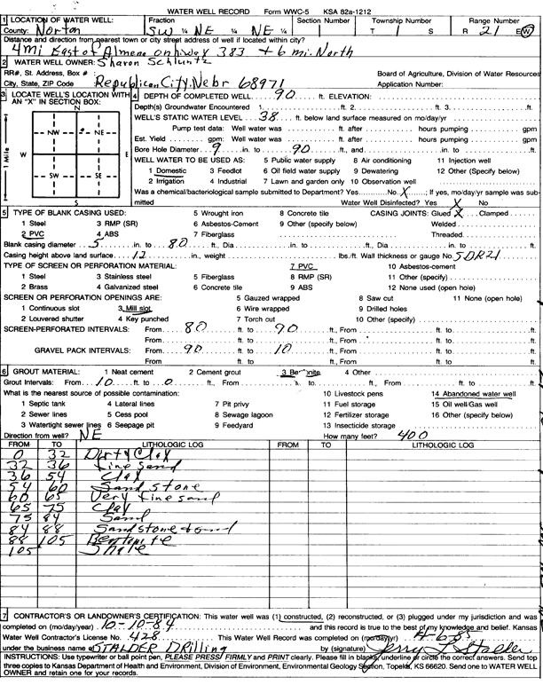
Specific Water Well Detail |
|
|
| Location Info | |||
| Owner: Schluntz, Sharon | Status: Constructed | ||
| Location: T1S, R21W, Sec. 1, SW NE NE | County: Norton | ||
| Directions: from Almena, 4 mi E on Hwy 383 and 6 mi N | |||
| Latitude: 39.9991482 | Longitude: -99.6285697 | Datum NAD 27 | |
| Latitude: 39.9991568 | Longitude: -99.6289573 | Datum NAD 83 | |
| Longitude and latitude calculated by Survey from township-range-section-quarter calls. Only good to within the quarter call accuracy. | |||
| View well on interactive map | |||
| General Info | ||
| Well Depth: 90 ft. | Elevation: ft. | |
| Static Water Level: 38 ft. | Est. Yield: gpm. | |
| Comp. Date: 10-Oct-1984 | Well Use: Domestic | |
| DWR Applic. #: | Other ID: | |
| Driller Info | ||
| Driller: Leo J. Stalder Drilling | License #: 428 | |
| Scanned Form | View scan |
|
Chemical Sample Submitted?: No
Water Well disinfected?: | ||
| Ground water encountered: 0 ft. , 0 ft. , 0 ft. | ||
| Pump test data: Well water was 0 ft after 0 hours pumping 0 gpm | ||
| Casing Info | ||
| Casing Type: PVC
Casing Joints: |
Diam: 5 in. to 80 ft
Diam: 0 in. to 0 ft Diam: 0 in. to 0 ft | |
| Casing height above land surface: in
Casing Weight: lbs/ft Wall thickness or gauge no.: | ||
| Screen and Perforation Info | ||
| Screen Type: PVC | Screen Openings: Mill slot | |
| Screen-perforated intervals | From: 890 ft to 0 ft
From: 0 ft to 0 ft From: 0 ft to 0 ft | |
| Gravel pack intervals | From: ft to ft | |
| Grout Info | ||
| Grout used: Bentonite | From: 0 to 0 ft
From: 0 to 0 ft From: 0 to 0 ft | |
| Source of Possible Contamination | ||
| Source: Abandoned water well | ||
| Direction from well: | Distance: 0 ft | |
| Lithologic Log
(Log data entered by KGS.) | ||
| From: 0 ft. to 32 ft. | dirty clay | |
| From: 32 ft. to 36 ft. | fine sand | |
| From: 36 ft. to 54 ft. | clay | |
| From: 54 ft. to 60 ft. | sandstone | |
| From: 60 ft. to 65 ft. | very fine sand | |
| From: 65 ft. to 75 ft. | clay | |
| From: 75 ft. to 84 ft. | sand | |
| From: 84 ft. to 88 ft. | sandstone and sand | |
| From: 88 ft. to 105 ft. | bentonite | |
| From: 105 ft. to ft. | shale | |