|
|
|
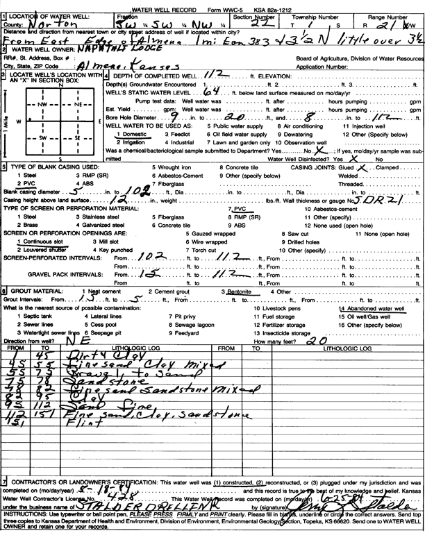
Specific Water Well Detail |
|
|
| Location Info | |||
| Owner: Naphtali Lodge | Status: Constructed | ||
| Location: T1S, R21W, Sec. 22, SW SW NW | County: Norton | ||
| Directions: from east edge of Almena, 1 mi E on Hwy 383 and 3.5 mi N | |||
| Latitude: 39.9518562 | Longitude: -99.6810884 | Datum NAD 27 | |
| Latitude: 39.951864 | Longitude: -99.6814784 | Datum NAD 83 | |
| Longitude and latitude calculated by Survey from township-range-section-quarter calls. Only good to within the quarter call accuracy. | |||
| View well on interactive map | |||
| General Info | ||
| Well Depth: 112 ft. | Elevation: ft. | |
| Static Water Level: 64 ft. | Est. Yield: gpm. | |
| Comp. Date: 18-May-1984 | Well Use: Domestic | |
| DWR Applic. #: | Other ID: | |
| Driller Info | ||
| Driller: Leo J. Stalder Drilling | License #: 428 | |
| Scanned Form | View scan |
|
Chemical Sample Submitted?: No
Water Well disinfected?: | ||
| Ground water encountered: 0 ft. , 0 ft. , 0 ft. | ||
| Pump test data: Well water was 0 ft after 0 hours pumping 0 gpm | ||
| Casing Info | ||
| Casing Type: PVC
Casing Joints: |
Diam: 5 in. to 102 ft
Diam: 0 in. to 0 ft Diam: 0 in. to 0 ft | |
| Casing height above land surface: in
Casing Weight: lbs/ft Wall thickness or gauge no.: | ||
| Screen and Perforation Info | ||
| Screen Type: PVC | Screen Openings: Continuous slot | |
| Screen-perforated intervals | From: 102 ft to 112 ft
From: 0 ft to 0 ft From: 0 ft to 0 ft | |
| Gravel pack intervals | From: ft to ft | |
| Grout Info | ||
| Grout used: Bentonite | From: 15 to 5 ft
From: 0 to 0 ft From: 0 to 0 ft | |
| Source of Possible Contamination | ||
| Source: Abandoned water well | ||
| Direction from well: | Distance: 0 ft | |
| Lithologic Log
(Log data entered by KGS.) | ||
| From: 1 ft. to 45 ft. | dirty clay | |
| From: 45 ft. to 55 ft. | fine sand clay mixed | |
| From: 55 ft. to 75 ft. | gravel to sand | |
| From: 75 ft. to 78 ft. | sandstone | |
| From: 78 ft. to 82 ft. | fine sand sandstone mixed | |
| From: 82 ft. to 95 ft. | clay | |
| From: 95 ft. to 112 ft. | sand fine | |
| From: 112 ft. to 151 ft. | fine sand, clay, sandstone | |
| From: 151 ft. to ft. | flint | |