|
|
|
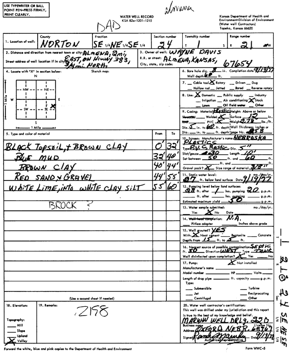
Specific Water Well Detail |
|
|
| Location Info | |||
| Owner: Davis, Wayne | Status: Constructed | ||
| Location: T1S, R21W, Sec. 24, SE NE SE | County: Norton | ||
| Directions: from Almena, 2 mi E on Hwy 383, 0.75 mi N | |||
| Latitude: 39.9484735 | Longitude: -99.6269814 | Datum NAD 27 | |
| Latitude: 39.9484818 | Longitude: -99.6273689 | Datum NAD 83 | |
| Longitude and latitude calculated by Survey from township-range-section-quarter calls. Only good to within the quarter call accuracy. | |||
| View well on interactive map | |||
| General Info | ||
| Well Depth: 60 ft. | Elevation: ft. | |
| Static Water Level: 27 ft. | Est. Yield: 50 gpm. | |
| Comp. Date: 19-Sep-1977 | Well Use: Domestic, Livestock | |
| DWR Applic. #: | Other ID: | |
| Driller Info | ||
| Driller: Maruhn Well Drlg., Inc. | License #: 220 | |
| Scanned Form | View scan |
|
Chemical Sample Submitted?: No
Water Well disinfected?: | ||
| Ground water encountered: 0 ft. , 0 ft. , 0 ft. | ||
| Pump test data: Well water was 0 ft after 0 hours pumping 0 gpm | ||
| Casing Info | ||
| Casing Type:
Casing Joints: |
Diam: 0 in. to 0 ft
Diam: 0 in. to 0 ft Diam: 0 in. to 0 ft | |
| Casing height above land surface: in
Casing Weight: lbs/ft Wall thickness or gauge no.: | ||
| Screen and Perforation Info | ||
| Screen Type: | Screen Openings: | |
| Screen-perforated intervals | From: 50 ft to 60 ft
From: 0 ft to 0 ft From: 0 ft to 0 ft | |
| Gravel pack intervals | From: ft to ft | |
| Grout Info | ||
| Grout used: | From: 0 to 0 ft
From: 0 to 0 ft From: 0 to 0 ft | |
| Source of Possible Contamination | ||
| Source: | ||
| Direction from well: | Distance: 0 ft | |
| Lithologic Log
(Log data entered by KGS.) | ||
| From: 0 ft. to 32 ft. | black topsoil and brown clay | |
| From: 32 ft. to 40 ft. | blue mud | |
| From: 40 ft. to 44 ft. | brown clay | |
| From: 44 ft. to 55 ft. | red sand and gravel | |
| From: 55 ft. to 60 ft. | white lime into white clay silt | |