|
|
|
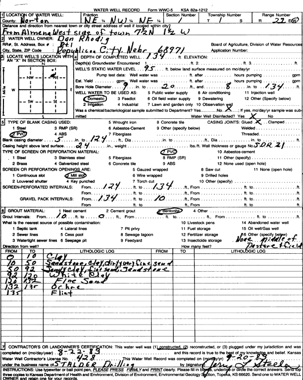
Specific Water Well Detail |
|
|
| Location Info | |||
| Owner: Rhodig, Dan | Status: Constructed | ||
| Location: T1S, R22W, Sec. 1, NE NW NE | County: Norton | ||
| Directions: From the West side of Almena, 7.5 miles North and 1.5 miles West | |||
| Latitude: 40.0009034 | Longitude: -99.7432246 | Datum NAD 27 | |
| Latitude: 40.0009109 | Longitude: -99.7436174 | Datum NAD 83 | |
| Longitude and latitude calculated by Survey from township-range-section-quarter calls. Only good to within the quarter call accuracy. | |||
| View well on interactive map | |||
| General Info | ||
| Well Depth: 134 ft. | Elevation: ft. | |
| Static Water Level: 95 ft. | Est. Yield: gpm. | |
| Comp. Date: 22-Aug-1983 | Well Use: Domestic | |
| DWR Applic. #: | Other ID: | |
| Driller Info | ||
| Driller: Leo J. Stalder Drilling | License #: 428 | |
| Scanned Form | View scan |
|
Chemical Sample Submitted?: No
Water Well disinfected?: | ||
| Ground water encountered: 0 ft. , 0 ft. , 0 ft. | ||
| Pump test data: Well water was 0 ft after 0 hours pumping 0 gpm | ||
| Casing Info | ||
| Casing Type:
Casing Joints: |
Diam: 0 in. to 0 ft
Diam: 0 in. to 0 ft Diam: 0 in. to 0 ft | |
| Casing height above land surface: in
Casing Weight: lbs/ft Wall thickness or gauge no.: | ||
| Screen and Perforation Info | ||
| Screen Type: | Screen Openings: | |
| Screen-perforated intervals | From: 124 ft to 134 ft
From: 0 ft to 0 ft From: 0 ft to 0 ft | |
| Gravel pack intervals | From: ft to ft | |
| Grout Info | ||
| Grout used: | From: 0 to 0 ft
From: 0 to 0 ft From: 0 to 0 ft | |
| Source of Possible Contamination | ||
| Source: | ||
| Direction from well: | Distance: 0 ft | |
| Lithologic Log
(Log data entered by KGS.) | ||
| From: 0 ft. to 10 ft. | clay | |
| From: 10 ft. to 50 ft. | sandstone, clay, dirty, very fine sand | |
| From: 50 ft. to 92 ft. | sandy clay, fine sand, sandstone | |
| From: 92 ft. to 120 ft. | white clay | |
| From: 120 ft. to 132 ft. | fine sand | |
| From: 132 ft. to 135 ft. | ochre | |
| From: 135 ft. to ft. | flint | |