|
|
|
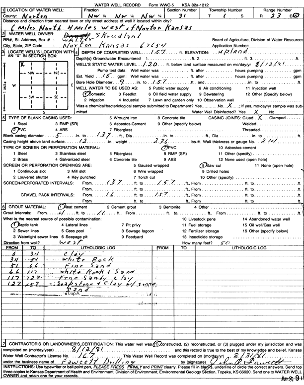
Specific Water Well Detail |
|
|
| Location Info | |||
| Owner: Skrdlant, Walter | Status: Constructed | ||
| Location: T1S, R23W, Sec. 31, NW NW NW | County: Norton | ||
| Directions: from Norton, 6 mi N and 4 mi W | |||
| Latitude: 39.9282512 | Longitude: -99.9621779 | Datum NAD 27 | |
| Latitude: 39.928257 | Longitude: -99.9625817 | Datum NAD 83 | |
| Longitude and latitude calculated by Survey from township-range-section-quarter calls. Only good to within the quarter call accuracy. | |||
| View well on interactive map | |||
| General Info | ||
| Well Depth: 157 ft. | Elevation: ft. | |
| Static Water Level: 120 ft. | Est. Yield: 15 gpm. | |
| Comp. Date: 12-Aug-1981 | Well Use: Domestic | |
| DWR Applic. #: | Other ID: | |
| Driller Info | ||
| Driller: John Fawcett Drilling Co. | License #: 167 | |
| Scanned Form | View scan |
|
Chemical Sample Submitted?: No
Water Well disinfected?: | ||
| Ground water encountered: 0 ft. , 0 ft. , 0 ft. | ||
| Pump test data: Well water was 0 ft after 0 hours pumping 0 gpm | ||
| Casing Info | ||
| Casing Type:
Casing Joints: |
Diam: 0 in. to 0 ft
Diam: 0 in. to 0 ft Diam: 0 in. to 0 ft | |
| Casing height above land surface: in
Casing Weight: lbs/ft Wall thickness or gauge no.: | ||
| Screen and Perforation Info | ||
| Screen Type: | Screen Openings: | |
| Screen-perforated intervals | From: 137 ft to 157 ft
From: 0 ft to 0 ft From: 0 ft to 0 ft | |
| Gravel pack intervals | From: ft to ft | |
| Grout Info | ||
| Grout used: | From: 0 to 0 ft
From: 0 to 0 ft From: 0 to 0 ft | |
| Source of Possible Contamination | ||
| Source: | ||
| Direction from well: | Distance: 0 ft | |
| Lithologic Log
(Log data entered by KGS.) | ||
| From: 0 ft. to 34 ft. | clay | |
| From: 34 ft. to 51 ft. | white rock | |
| From: 51 ft. to 66 ft. | fine sand | |
| From: 66 ft. to 117 ft. | white rock and sand | |
| From: 117 ft. to 127 ft. | fine sand clay | |
| From: 127 ft. to 157 ft. | sandstone and clay with some sand | |