|
|
|
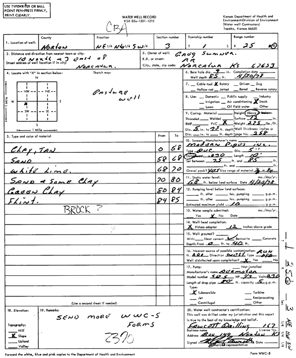
Specific Water Well Detail |
|
|
| Location Info | |||
| Owner: Sumner, Greg | Status: Constructed | ||
| Location: T1S, R25W, Sec. 3, NE NW SW | County: Norton | ||
| Directions: from Norcatur, 10 mi N and 3 mi E | |||
| Latitude: 39.9933703 | Longitude: -100.1275938 | Datum NAD 27 | |
| Latitude: 39.9933761 | Longitude: -100.1280057 | Datum NAD 83 | |
| Longitude and latitude calculated by Survey from township-range-section-quarter calls. Only good to within the quarter call accuracy. | |||
| View well on interactive map | |||
| General Info | ||
| Well Depth: 85 ft. | Elevation: ft. | |
| Static Water Level: 68 ft. | Est. Yield: 10 gpm. | |
| Comp. Date: 20-Apr-1978 | Well Use: Domestic, Livestock | |
| DWR Applic. #: | Other ID: | |
| Driller Info | ||
| Driller: John Fawcett Drilling Co. | License #: 167 | |
| Scanned Form | View scan |
|
Chemical Sample Submitted?: No
Water Well disinfected?: | ||
| Ground water encountered: 0 ft. , 0 ft. , 0 ft. | ||
| Pump test data: Well water was 0 ft after 0 hours pumping 0 gpm | ||
| Casing Info | ||
| Casing Type:
Casing Joints: |
Diam: 0 in. to 0 ft
Diam: 0 in. to 0 ft Diam: 0 in. to 0 ft | |
| Casing height above land surface: in
Casing Weight: lbs/ft Wall thickness or gauge no.: | ||
| Screen and Perforation Info | ||
| Screen Type: | Screen Openings: | |
| Screen-perforated intervals | From: 75 ft to 85 ft
From: 0 ft to 0 ft From: 0 ft to 0 ft | |
| Gravel pack intervals | From: ft to ft | |
| Grout Info | ||
| Grout used: | From: 0 to 0 ft
From: 0 to 0 ft From: 0 to 0 ft | |
| Source of Possible Contamination | ||
| Source: | ||
| Direction from well: | Distance: 0 ft | |
| Lithologic Log
(Log data entered by KGS.) | ||
| From: 0 ft. to 58 ft. | clay, tan | |
| From: 58 ft. to 68 ft. | sand | |
| From: 68 ft. to 70 ft. | white lime | |
| From: 70 ft. to 80 ft. | sand and some clay | |
| From: 80 ft. to 84 ft. | green clay | |
| From: 84 ft. to 85 ft. | flint | |