|
|
|
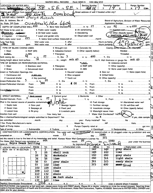
Specific Water Well Detail |
|
|
| Location Info | |||
| Owner: Micheals, George | Status: Constructed | ||
| Location: T14S, R17E, Sec. 15, SE SE SE | County: Osage | ||
| Directions: from Overbrook, 2 mi E and 3.25 mi N | |||
| Latitude: 38.8267601 | Longitude: -95.5013794 | Datum NAD 27 | |
| Latitude: 38.8267643 | Longitude: -95.5016358 | Datum NAD 83 | |
| Longitude and latitude calculated by Survey from township-range-section-quarter calls. Only good to within the quarter call accuracy. | |||
| View well on interactive map | |||
| General Info | ||
| Well Depth: 400 ft. | Elevation: 1030 ft. | |
| Static Water Level: 295 ft. | Est. Yield: 20 gpm. | |
| Comp. Date: 15-Sep-1980 | Well Use: Pond/Swimming Pool/Recreation | |
| DWR Applic. #: | Other ID: | |
| Driller Info | ||
| Driller: Royce Swank Drilling | License #: 371 | |
| Scanned Form | View scan |
|
Chemical Sample Submitted?: No
Water Well disinfected?: | ||
| Ground water encountered: 0 ft. , 0 ft. , 0 ft. | ||
| Pump test data: Well water was 0 ft after 0 hours pumping 0 gpm | ||
| Casing Info | ||
| Casing Type:
Casing Joints: |
Diam: 0 in. to 0 ft
Diam: 0 in. to 0 ft Diam: 0 in. to 0 ft | |
| Casing height above land surface: in
Casing Weight: lbs/ft Wall thickness or gauge no.: | ||
| Screen and Perforation Info | ||
| Screen Type: | Screen Openings: | |
| Screen-perforated intervals | From: 380 ft to 400 ft
From: 0 ft to 0 ft From: 0 ft to 0 ft | |
| Gravel pack intervals | From: ft to ft | |
| Grout Info | ||
| Grout used: | From: 0 to 0 ft
From: 0 to 0 ft From: 0 to 0 ft | |
| Source of Possible Contamination | ||
| Source: | ||
| Direction from well: | Distance: 0 ft | |
| Lithologic Log
(Log data entered by KGS.) | ||
| From: 0 ft. to 5 ft. | soil | |
| From: 5 ft. to 26 ft. | shell rock | |
| From: 26 ft. to 34 ft. | dark shale | |
| From: 34 ft. to 56 ft. | limestone | |
| From: 56 ft. to 61 ft. | gray shale | |
| From: 61 ft. to 102 ft. | limestone | |
| From: 102 ft. to 109 ft. | shale | |
| From: 109 ft. to 112 ft. | limestone | |
| From: 112 ft. to 132 ft. | shale | |
| From: 132 ft. to 137 ft. | dark shale | |
| From: 137 ft. to 142 ft. | limestone | |
| From: 142 ft. to 148 ft. | gray shale | |
| From: 148 ft. to 160 ft. | limestone | |
| From: 160 ft. to 260 ft. | gray shale | |
| From: 260 ft. to 311 ft. | light shale | |
| From: 311 ft. to 325 ft. | sandy shale | |
| From: 325 ft. to 400 ft. | sand | |