|
|
|
Specific Water Well Detail |
|
|
| Location Info | |||
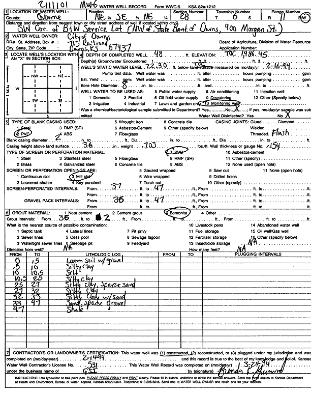
| Owner: City of Downs | Status: Constructed | ||
| Location: T6S, R11W, Sec. 28, NE SE NE | County: Osborne | ||
| Directions: SW corner of B and W Service lot; NW of State Bank of Downs, 900 Morgan St | |||
| Latitude: 39.5047584 | Longitude: -98.5452157 | Datum NAD 27 | |
| Latitude: 39.5047689 | Longitude: -98.545559 | Datum NAD 83 | |
| Longitude and latitude calculated by Survey from township-range-section-quarter calls. Only good to within the quarter call accuracy. | |||
| View well on interactive map | |||
| General Info | ||
| Well Depth: 48 ft. | Elevation: 1486 ft. | |
| Static Water Level: 22.3 ft. | Est. Yield: gpm. | |
| Comp. Date: 14-Feb-1994 | Well Use: Monitoring well/observation/piezometer | |
| DWR Applic. #: | Other ID: MW 6 | |
| Driller Info | ||
| Driller: Geotechnical Services, Inc. | License #: 531 | |
| Scanned Form | View scan |
|
Chemical Sample Submitted?: No
Water Well disinfected?: | ||
| Ground water encountered: 0 ft. , 0 ft. , 0 ft. | ||
| Pump test data: Well water was 0 ft after 0 hours pumping 0 gpm | ||
| Casing Info | ||
| Casing Type: PVC
Casing Joints: |
Diam: 2 in. to 0 ft
Diam: 0 in. to 0 ft Diam: 0 in. to 0 ft | |
| Casing height above land surface: in
Casing Weight: lbs/ft Wall thickness or gauge no.: | ||
| Screen and Perforation Info | ||
| Screen Type: PVC | Screen Openings: Mill slot | |
| Screen-perforated intervals | From: 37 ft to 47 ft
From: 0 ft to 0 ft From: 0 ft to 0 ft | |
| Gravel pack intervals | From: ft to ft | |
| Grout Info | ||
| Grout used: Bentonite | From: 2 to 36 ft
From: 0 to 0 ft From: 0 to 0 ft | |
| Source of Possible Contamination | ||
| Source: OTHER | ||
| Direction from well: | Distance: 0 ft | |
| Lithologic Log
(Log data entered by KGS.) | ||
| From: 0 ft. to .5 ft. | loam soil with gravel | |
| From: .5 ft. to 10 ft. | silty clay | |
| From: 10 ft. to 10.5 ft. | silt | |
| From: 10.5 ft. to 25 ft. | silty clay | |
| From: 25 ft. to 27 ft. | silty clay, sparse sand | |
| From: 27 ft. to 32 ft. | silty clay | |
| From: 32 ft. to 33 ft. | silty clay with sand | |
| From: 33 ft. to 47 ft. | sand, sparse gravel | |
| From: 47 ft. to ft. | shale | |