|
|
|
Specific Water Well Detail |
|
|
| Location Info | |||
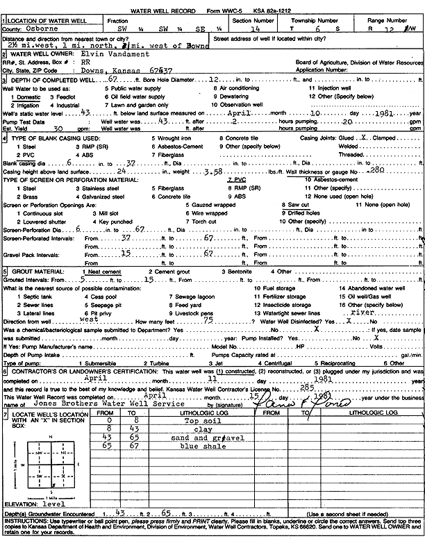
| Owner: Vandament, Elvin | Status: Constructed | ||
| Location: T6S, R12W, Sec. 14, SW SW SE | County: Osborne | ||
| Directions: from Downs, 2.5 mi W, 1 mi N, and 1 mi W | |||
| Latitude: 39.5250634 | Longitude: -98.6259498 | Datum NAD 27 | |
| Latitude: 39.5250741 | Longitude: -98.6262967 | Datum NAD 83 | |
| Longitude and latitude calculated by Survey from township-range-section-quarter calls. Only good to within the quarter call accuracy. | |||
| View well on interactive map | |||
| General Info | ||
| Well Depth: 67 ft. | Elevation: ft. | |
| Static Water Level: 43 ft. | Est. Yield: 30 gpm. | |
| Comp. Date: 11-Apr-1981 | Well Use: Domestic | |
| DWR Applic. #: | Other ID: | |
| Driller Info | ||
| Driller: James F. Jones Bros. Water Well Service | License #: 285 | |
| Scanned Form | View scan |
|
Chemical Sample Submitted?: No
Water Well disinfected?: | ||
| Ground water encountered: 0 ft. , 0 ft. , 0 ft. | ||
| Pump test data: Well water was 0 ft after 0 hours pumping 0 gpm | ||
| Casing Info | ||
| Casing Type:
Casing Joints: |
Diam: 0 in. to 0 ft
Diam: 0 in. to 0 ft Diam: 0 in. to 0 ft | |
| Casing height above land surface: in
Casing Weight: lbs/ft Wall thickness or gauge no.: | ||
| Screen and Perforation Info | ||
| Screen Type: | Screen Openings: | |
| Screen-perforated intervals | From: 37 ft to 67 ft
From: 0 ft to 0 ft From: 0 ft to 0 ft | |
| Gravel pack intervals | From: ft to ft | |
| Grout Info | ||
| Grout used: | From: 0 to 0 ft
From: 0 to 0 ft From: 0 to 0 ft | |
| Source of Possible Contamination | ||
| Source: | ||
| Direction from well: | Distance: 0 ft | |
| Lithologic Log
(Log data entered by KGS.) | ||
| From: 0 ft. to 8 ft. | top soil | |
| From: 8 ft. to 43 ft. | clay | |
| From: 43 ft. to 65 ft. | sand and gravel | |
| From: 65 ft. to 67 ft. | blue shale | |