|
|
|
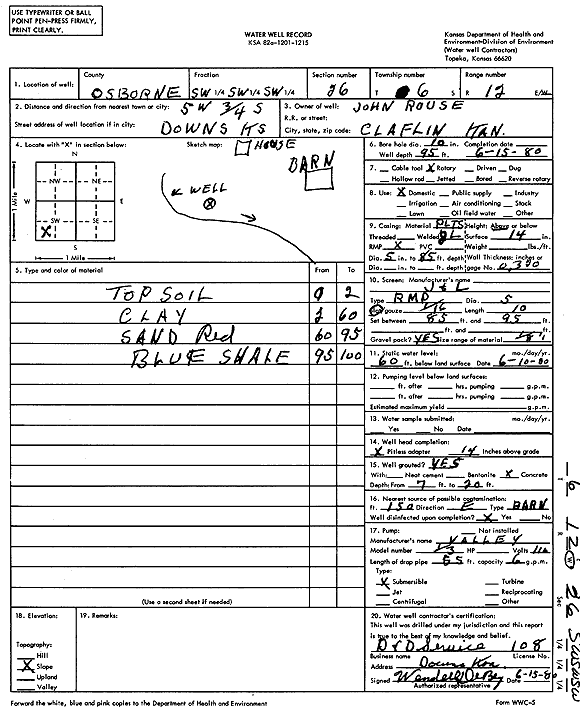
Specific Water Well Detail |
|
|
| Location Info | |||
| Owner: Rouse, John | Status: Constructed | ||
| Location: T6S, R12W, Sec. 26, SW SW SW | County: Osborne | ||
| Directions: from Downs, 5 mi W and 0.75 mi S | |||
| Latitude: 39.4960851 | Longitude: -98.6359473 | Datum NAD 27 | |
| Latitude: 39.4960955 | Longitude: -98.6362949 | Datum NAD 83 | |
| Longitude and latitude calculated by Survey from township-range-section-quarter calls. Only good to within the quarter call accuracy. | |||
| View well on interactive map | |||
| General Info | ||
| Well Depth: 95 ft. | Elevation: ft. | |
| Static Water Level: 60 ft. | Est. Yield: gpm. | |
| Comp. Date: 15-Jun-1980 | Well Use: Domestic | |
| DWR Applic. #: | Other ID: | |
| Driller Info | ||
| Driller: D & D Service | License #: 108 | |
| Scanned Form | View scan |
|
Chemical Sample Submitted?: No
Water Well disinfected?: | ||
| Ground water encountered: 0 ft. , 0 ft. , 0 ft. | ||
| Pump test data: Well water was 0 ft after 0 hours pumping 0 gpm | ||
| Casing Info | ||
| Casing Type:
Casing Joints: |
Diam: 0 in. to 0 ft
Diam: 0 in. to 0 ft Diam: 0 in. to 0 ft | |
| Casing height above land surface: in
Casing Weight: lbs/ft Wall thickness or gauge no.: | ||
| Screen and Perforation Info | ||
| Screen Type: | Screen Openings: | |
| Screen-perforated intervals | From: 85 ft to 95 ft
From: 0 ft to 0 ft From: 0 ft to 0 ft | |
| Gravel pack intervals | From: ft to ft | |
| Grout Info | ||
| Grout used: | From: 0 to 0 ft
From: 0 to 0 ft From: 0 to 0 ft | |
| Source of Possible Contamination | ||
| Source: | ||
| Direction from well: | Distance: 0 ft | |
| Lithologic Log
(Log data entered by KGS.) | ||
| From: 0 ft. to 2 ft. | top soil | |
| From: 2 ft. to 60 ft. | clay | |
| From: 60 ft. to 95 ft. | sand, red | |
| From: 95 ft. to 100 ft. | blue shale | |