|
|
|
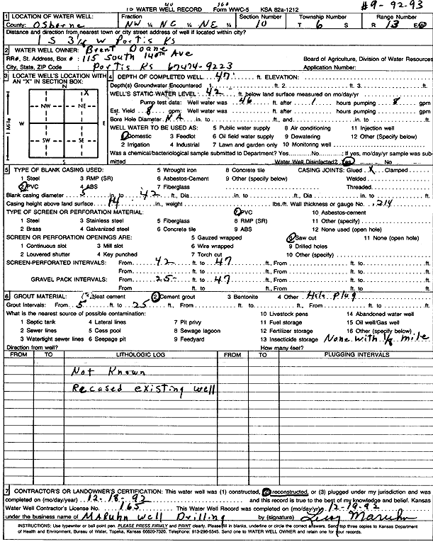
Specific Water Well Detail |
|
|
| Location Info | |||
| Owner: Doane, Brent | Status: Reconstructed | ||
| Location: T6S, R13W, Sec. 10, NW NE NE | County: Osborne | ||
| Directions: from Portis, 1 mi S and 3.13 mi W | |||
| Latitude: 39.5530681 | Longitude: -98.7514317 | Datum NAD 27 | |
| Latitude: 39.553079 | Longitude: -98.7517842 | Datum NAD 83 | |
| Longitude and latitude calculated by Survey from township-range-section-quarter calls. Only good to within the quarter call accuracy. | |||
| View well on interactive map | |||
| General Info | ||
| Well Depth: 47 ft. | Elevation: ft. | |
| Static Water Level: 42 ft. | Est. Yield: 8 gpm. | |
| Comp. Date: 18-Dec-1992 | Well Use: Domestic | |
| DWR Applic. #: | Other ID: | |
| Links | |
| View info from Wizard Water Level Data base... | |
| No WIMAS information available. | |
| Driller Info | ||
| Driller: Leroy Maruhn Well Drilling, Inc. | License #: 165 | |
| Scanned Form | View scan |
|
Chemical Sample Submitted?: No
Water Well disinfected?: | ||
| Ground water encountered: 0 ft. , 0 ft. , 0 ft. | ||
| Pump test data: Well water was 46 ft after 1 hours pumping 8 gpm | ||
| Casing Info | ||
| Casing Type: PVC
Casing Joints: |
Diam: 5 in. to 42 ft
Diam: 0 in. to 0 ft Diam: 0 in. to 0 ft | |
| Casing height above land surface: in
Casing Weight: lbs/ft Wall thickness or gauge no.: | ||
| Screen and Perforation Info | ||
| Screen Type: PVC | Screen Openings: Saw cut | |
| Screen-perforated intervals | From: 42 ft to 47 ft
From: 0 ft to 0 ft From: 0 ft to 0 ft | |
| Gravel pack intervals | From: ft to ft | |
| Grout Info | ||
| Grout used: Neat cement, Cement grout | From: 5 to 25 ft
From: 0 to 0 ft From: 0 to 0 ft | |
| Source of Possible Contamination | ||
| Source: OTHER | ||
| Direction from well: | Distance: 0 ft | |