|
|
|
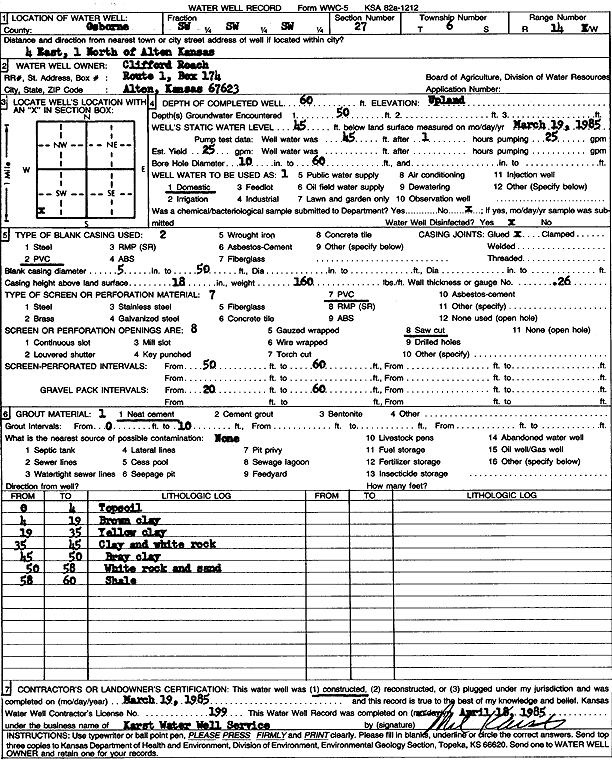
Specific Water Well Detail |
|
|
| Location Info | |||
| Owner: Roach, Clifford | Status: Constructed | ||
| Location: T6S, R14W, Sec. 27, SW SW SW | County: Osborne | ||
| Directions: From Alton, 4 miles East, 1 mile North | |||
| Latitude: 39.4970731 | Longitude: -98.8760221 | Datum NAD 27 | |
| Latitude: 39.4970836 | Longitude: -98.8763799 | Datum NAD 83 | |
| Longitude and latitude calculated by Survey from township-range-section-quarter calls. Only good to within the quarter call accuracy. | |||
| View well on interactive map | |||
| General Info | ||
| Well Depth: 60 ft. | Elevation: ft. | |
| Static Water Level: 45 ft. | Est. Yield: 25 gpm. | |
| Comp. Date: 19-Mar-1985 | Well Use: Domestic | |
| DWR Applic. #: | Other ID: | |
| Driller Info | ||
| Driller: Melvin B. Karst Water Well Drilling & Service, Inc. | License #: 199 | |
| Scanned Form | View scan |
|
Chemical Sample Submitted?: No
Water Well disinfected?: | ||
| Ground water encountered: 50 ft. , 0 ft. , 0 ft. | ||
| Pump test data: Well water was 45 ft after 1 hours pumping 25 gpm | ||
| Casing Info | ||
| Casing Type: PVC
Casing Joints: |
Diam: 5 in. to 50 ft
Diam: 0 in. to 0 ft Diam: 0 in. to 0 ft | |
| Casing height above land surface: in
Casing Weight: lbs/ft Wall thickness or gauge no.: | ||
| Screen and Perforation Info | ||
| Screen Type: PVC | Screen Openings: Saw cut | |
| Screen-perforated intervals | From: 50 ft to 60 ft
From: 0 ft to 0 ft From: 0 ft to 0 ft | |
| Gravel pack intervals | From: ft to ft | |
| Grout Info | ||
| Grout used: Neat cement | From: 0 to 10 ft
From: 0 to 0 ft From: 0 to 0 ft | |
| Source of Possible Contamination | ||
| Source: | ||
| Direction from well: | Distance: 0 ft | |
| Lithologic Log
(Log data entered by KGS.) | ||
| From: 0 ft. to 4 ft. | top soil | |
| From: 4 ft. to 19 ft. | brown clay | |
| From: 19 ft. to 35 ft. | yellow clay | |
| From: 35 ft. to 45 ft. | clay and white rock | |
| From: 45 ft. to 50 ft. | gray clay | |
| From: 50 ft. to 58 ft. | white rock and sand | |
| From: 58 ft. to 60 ft. | shale | |