|
|
|
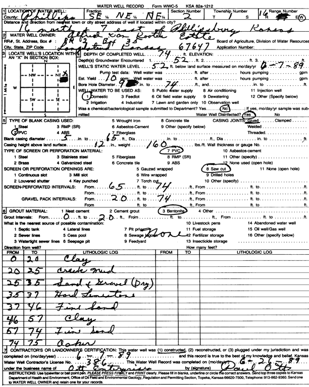
Specific Water Well Detail |
|
|
| Location Info | |||
| Owner: Alfred Van Kooten Estate | Status: Constructed | ||
| Location: T1S, R16W, Sec. 2, SE NE NE | County: Phillips | ||
| Directions: from Phillipsburg, 16 mi N and 7 mi E | |||
| Latitude: 39.9995534 | Longitude: -99.0865292 | Datum NAD 27 | |
| Latitude: 39.999566 | Longitude: -99.0868929 | Datum NAD 83 | |
| Longitude and latitude calculated by Survey from township-range-section-quarter calls. Only good to within the quarter call accuracy. | |||
| View well on interactive map | |||
| General Info | ||
| Well Depth: 74 ft. | Elevation: ft. | |
| Static Water Level: 52 ft. | Est. Yield: 10 gpm. | |
| Comp. Date: 07-Jun-1989 | Well Use: Domestic | |
| DWR Applic. #: | Other ID: | |
| Driller Info | ||
| Driller: Paul Ott Enterprises | License #: 386 | |
| Scanned Form | View scan |
|
Chemical Sample Submitted?: No
Water Well disinfected?: | ||
| Ground water encountered: 52 ft. , 0 ft. , 0 ft. | ||
| Pump test data: Well water was 0 ft after 0 hours pumping 0 gpm | ||
| Casing Info | ||
| Casing Type: PVC
Casing Joints: |
Diam: 5 in. to 65 ft
Diam: 0 in. to 0 ft Diam: 0 in. to 0 ft | |
| Casing height above land surface: in
Casing Weight: lbs/ft Wall thickness or gauge no.: | ||
| Screen and Perforation Info | ||
| Screen Type: PVC | Screen Openings: Saw cut | |
| Screen-perforated intervals | From: 65 ft to 74 ft
From: 0 ft to 0 ft From: 0 ft to 0 ft | |
| Gravel pack intervals | From: ft to ft | |
| Grout Info | ||
| Grout used: Bentonite | From: 0 to 20 ft
From: 0 to 0 ft From: 0 to 0 ft | |
| Source of Possible Contamination | ||
| Source: OTHER | ||
| Direction from well: | Distance: 0 ft | |
| Lithologic Log
(Log data entered by KGS.) | ||
| From: 0 ft. to 20 ft. | clay | |
| From: 20 ft. to 25 ft. | creek mud | |
| From: 25 ft. to 35 ft. | sand and gravel, dry | |
| From: 35 ft. to 37 ft. | hard limestone | |
| From: 37 ft. to 46 ft. | fine sand | |
| From: 46 ft. to 57 ft. | clay | |
| From: 57 ft. to 74 ft. | fine sand | |
| From: 74 ft. to 75 ft. | ochre | |