|
|
|
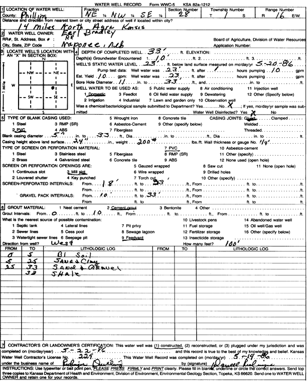
Specific Water Well Detail |
|
|
| Location Info | |||
| Owner: Bradley, Earl | Status: Constructed | ||
| Location: T1S, R16W, Sec. 28, NE NW SE | County: Phillips | ||
| Directions: from Agra, 14 mi N | |||
| Latitude: 39.9363589 | Longitude: -99.1288967 | Datum NAD 27 | |
| Latitude: 39.9363708 | Longitude: -99.1292622 | Datum NAD 83 | |
| Longitude and latitude calculated by Survey from township-range-section-quarter calls. Only good to within the quarter call accuracy. | |||
| View well on interactive map | |||
| General Info | ||
| Well Depth: 33 ft. | Elevation: ft. | |
| Static Water Level: 23 ft. | Est. Yield: 10 gpm. | |
| Comp. Date: 22-May-1986 | Well Use: Domestic | |
| DWR Applic. #: | Other ID: | |
| Driller Info | ||
| Driller: Darrell D. Redinger Drilling & Trenching | License #: 229 | |
| Scanned Form | View scan |
|
Chemical Sample Submitted?: No
Water Well disinfected?: | ||
| Ground water encountered: 10 ft. , 0 ft. , 0 ft. | ||
| Pump test data: Well water was 23 ft after 1 hours pumping 10 gpm | ||
| Casing Info | ||
| Casing Type: PVC
Casing Joints: |
Diam: 5 in. to 33 ft
Diam: 0 in. to 0 ft Diam: 0 in. to 0 ft | |
| Casing height above land surface: in
Casing Weight: lbs/ft Wall thickness or gauge no.: | ||
| Screen and Perforation Info | ||
| Screen Type: PVC | Screen Openings: Mill slot | |
| Screen-perforated intervals | From: 18 ft to 33 ft
From: 0 ft to 0 ft From: 0 ft to 0 ft | |
| Gravel pack intervals | From: ft to ft | |
| Grout Info | ||
| Grout used: Cement grout | From: 0 to 10 ft
From: 0 to 0 ft From: 0 to 0 ft | |
| Source of Possible Contamination | ||
| Source: Feedyard | ||
| Direction from well: | Distance: 0 ft | |
| Lithologic Log
(Log data entered by KGS.) | ||
| From: 0 ft. to 5 ft. | black soil | |
| From: 5 ft. to 25 ft. | sand and clay | |
| From: 25 ft. to 33 ft. | sand and gravel | |
| From: ft. to 33 ft. | shale | |