|
|
|
Specific Water Well Detail |
|
|
| Location Info | |||
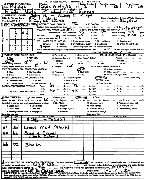
| Owner: Knape, John and Nancy | Status: Constructed | ||
| Location: T1S, R19W, Sec. 2, SW NW NE | County: Phillips | ||
| Directions: from Woodruff, 0.5 mi N | |||
| Latitude: 39.9993354 | Longitude: -99.4300434 | Datum NAD 27 | |
| Latitude: 39.9993457 | Longitude: -99.430422 | Datum NAD 83 | |
| Longitude and latitude calculated by Survey from township-range-section-quarter calls. Only good to within the quarter call accuracy. | |||
| View well on interactive map | |||
| General Info | ||
| Well Depth: 72 ft. | Elevation: ft. | |
| Static Water Level: 35 ft. | Est. Yield: gpm. | |
| Comp. Date: 24-Dec-1986 | Well Use: Irrigation | |
| DWR Applic. #: 36843 | Other ID: | |
| Links | |
| No Wizard information available. | |
| View info from WIMAS Water Right Data base... | |
| Driller Info | ||
| Driller: Paul Ott Enterprises | License #: 386 | |
| Scanned Form | View scan |
|
Chemical Sample Submitted?: No
Water Well disinfected?: | ||
| Ground water encountered: 0 ft. , 0 ft. , 0 ft. | ||
| Pump test data: Well water was 55 ft after 0 hours pumping 150 gpm | ||
| Casing Info | ||
| Casing Type: PVC
Casing Joints: |
Diam: 8 in. to 61 ft
Diam: 0 in. to 0 ft Diam: 0 in. to 0 ft | |
| Casing height above land surface: in
Casing Weight: lbs/ft Wall thickness or gauge no.: | ||
| Screen and Perforation Info | ||
| Screen Type: PVC | Screen Openings: Saw cut | |
| Screen-perforated intervals | From: 61 ft to 72 ft
From: 0 ft to 0 ft From: 0 ft to 0 ft | |
| Gravel pack intervals | From: ft to ft | |
| Grout Info | ||
| Grout used: Bentonite | From: 10 to 20 ft
From: 0 to 0 ft From: 0 to 0 ft | |
| Source of Possible Contamination | ||
| Source: | ||
| Direction from well: | Distance: 0 ft | |
| Lithologic Log
(Log data entered by KGS.) | ||
| From: 0 ft. to 41 ft. | clay and topsoil | |
| From: 41 ft. to 55 ft. | creek mud (black) | |
| From: 55 ft. to 66 ft. | sand and gravel (dark color) | |
| From: 66 ft. to 72 ft. | shale | |