|
|
|
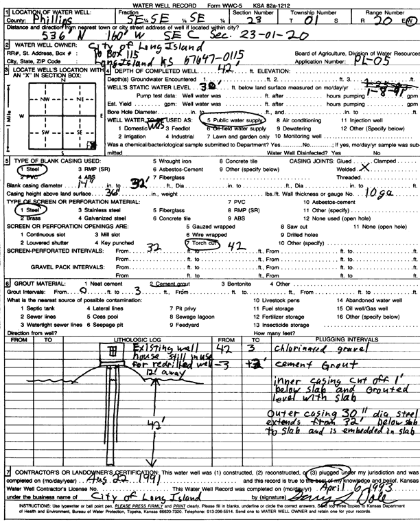
Specific Water Well Detail |
|
|
| Location Info | |||
| Owner: City of Long Island | Status: Plugged | ||
| Location: T1S, R20W, Sec. 23, SE SE SE | County: Phillips | ||
| Directions: from SE corner, 536 feet N and 160 feet W | |||
| Latitude: 39.9449275 | Longitude: -99.5347148 | Datum NAD 27 | |
| Latitude: 39.9449367 | Longitude: -99.535098 | Datum NAD 83 | |
| Longitude and latitude calculated by Survey from township-range-section-quarter calls. Only good to within the quarter call accuracy. | |||
| View well on interactive map | |||
| General Info | ||
| Well Depth: 42 ft. | Elevation: ft. | |
| Static Water Level: 30 ft. | Est. Yield: gpm. | |
| Comp. Date: 22-Aug-1991 | Well Use: Public Water Supply | |
| DWR Applic. #: PL-05 | Other ID: | |
| Links | |
| View info from Wizard Water Level Data base... | |
| No WIMAS information available. | |
| Driller Info | ||
| Driller: City of Long Island | License #: | |
| Scanned Form | View scan |
| Casing Info | ||
|
Casing Type: Steel
Diam: 14 in. Casing height above land surface: in | ||
| Grout Info | ||
| Grout used: Cement grout | From: 0 to 3 ft
From: 0 to 0 ft From: 0 to 0 ft | |
| Source of Possible Contamination | ||
| Source: OTHER | ||
| Direction from well: | Distance: 0 ft | |