|
|
|
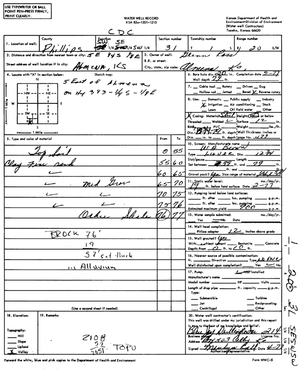
Specific Water Well Detail |
|
|
| Location Info | |||
| Owner: Ross, Glenn | Status: Constructed | ||
| Location: T1S, R20W, Sec. 31, SE SW SW | County: Phillips | ||
| Directions: from Almena, 5 mi E, 0.25 mi S, and 0.12 mi E | |||
| Latitude: 39.9158449 | Longitude: -99.6229937 | Datum NAD 27 | |
| Latitude: 39.9158532 | Longitude: -99.6233811 | Datum NAD 83 | |
| Longitude and latitude calculated by Survey from township-range-section-quarter calls. Only good to within the quarter call accuracy. | |||
| View well on interactive map | |||
| General Info | ||
| Well Depth: 79 ft. | Elevation: ft. | |
| Static Water Level: 19 ft. | Est. Yield: 900 gpm. | |
| Comp. Date: 01-Feb-1977 | Well Use: Domestic | |
| DWR Applic. #: | Other ID: | |
| Driller Info | ||
| Driller: Blue Jay Drilling Co., Inc. | License #: 214 | |
| Scanned Form | View scan |
|
Chemical Sample Submitted?: No
Water Well disinfected?: | ||
| Ground water encountered: 0 ft. , 0 ft. , 0 ft. | ||
| Pump test data: Well water was 0 ft after 0 hours pumping 0 gpm | ||
| Casing Info | ||
| Casing Type:
Casing Joints: |
Diam: 0 in. to 0 ft
Diam: 0 in. to 0 ft Diam: 0 in. to 0 ft | |
| Casing height above land surface: in
Casing Weight: lbs/ft Wall thickness or gauge no.: | ||
| Screen and Perforation Info | ||
| Screen Type: | Screen Openings: | |
| Screen-perforated intervals | From: 39 ft to 79 ft
From: 0 ft to 0 ft From: 0 ft to 0 ft | |
| Gravel pack intervals | From: ft to ft | |
| Grout Info | ||
| Grout used: | From: 0 to 0 ft
From: 0 to 0 ft From: 0 to 0 ft | |
| Source of Possible Contamination | ||
| Source: | ||
| Direction from well: | Distance: 0 ft | |
| Lithologic Log
(Log data entered by KGS.) | ||
| From: 0 ft. to 55 ft. | topsoil | |
| From: 55 ft. to 60 ft. | clay fine sand | |
| From: 60 ft. to 65 ft. | fine sand, medium gravel | |
| From: 65 ft. to 70 ft. | fine sand, medium gravel | |
| From: 70 ft. to 75 ft. | fine sand, medium gravel | |
| From: 75 ft. to 76 ft. | fine sand, medium gravel | |
| From: 76 ft. to 77 ft. | ochre, shale | |