|
|
|
Specific Water Well Detail |
|
|
| Location Info | |||
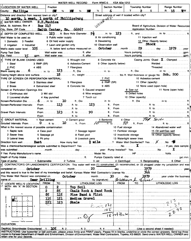
| Owner: Faubion, H.H. | Status: Constructed | ||
| Location: T2S, R18W, Sec. 6, SW NW NW | County: Phillips | ||
| Directions: from Phillipsburg, 10 mi N, 4 mi W, and 1 mi N | |||
| Latitude: 39.9124253 | Longitude: -99.4014187 | Datum NAD 27 | |
| Latitude: 39.9124353 | Longitude: -99.4017962 | Datum NAD 83 | |
| Longitude and latitude calculated by Survey from township-range-section-quarter calls. Only good to within the quarter call accuracy. | |||
| View well on interactive map | |||
| General Info | ||
| Well Depth: 123 ft. | Elevation: ft. | |
| Static Water Level: 105 ft. | Est. Yield: 15 gpm. | |
| Comp. Date: 20-Oct-1979 | Well Use: Domestic, Livestock | |
| DWR Applic. #: | Other ID: | |
| Links | |
| View info from Wizard Water Level Data base... | |
| No WIMAS information available. | |
| Driller Info | ||
| Driller: William J. Deer Drilling | License #: 344 | |
| Scanned Form | View scan |
|
Chemical Sample Submitted?: No
Water Well disinfected?: Yes | ||
| Ground water encountered: 0 ft. , 0 ft. , 0 ft. | ||
| Pump test data: Well water was 0 ft after 0 hours pumping 0 gpm | ||
| Bore hole diameter: 9.5 inches to 123 ft | ||
| Casing Info | ||
| Casing Type: PVC
Casing Joints: Glued |
Diam: 6 in. to 123 ft
Diam: 0 in. to 0 ft Diam: 0 in. to 0 ft | |
| Casing height above land surface: 18 in
Casing Weight: lbs/ft Wall thickness or gauge no.: Sch. 200 | ||
| Screen and Perforation Info | ||
| Screen Type: PVC | Screen Openings: Saw cut | |
| Screen-perforated intervals | From: 113 ft to 123 ft
From: 0 ft to 0 ft From: 0 ft to 0 ft | |
| Gravel pack intervals | From: 123 ft to 90 ft | |
| Grout Info | ||
| Grout used: Bentonite, Top Soil | From: 0 to 10 ft
From: 10 to 90 ft From: 0 to 0 ft | |
| Source of Possible Contamination | ||
| Source: Oil well/gas well | ||
| Direction from well: East | Distance: 2640 ft | |
| Lithologic Log
(Log data entered by KGS.) | ||
| From: 0 ft. to 2 ft. | topsoil | |
| From: 2 ft. to 85 ft. | chalk rock and sand rock | |
| From: 85 ft. to 115 ft. | fine sand and flint | |
| From: 115 ft. to 121 ft. | medium gravel | |
| From: 121 ft. to 123 ft. | shale | |