|
|
|
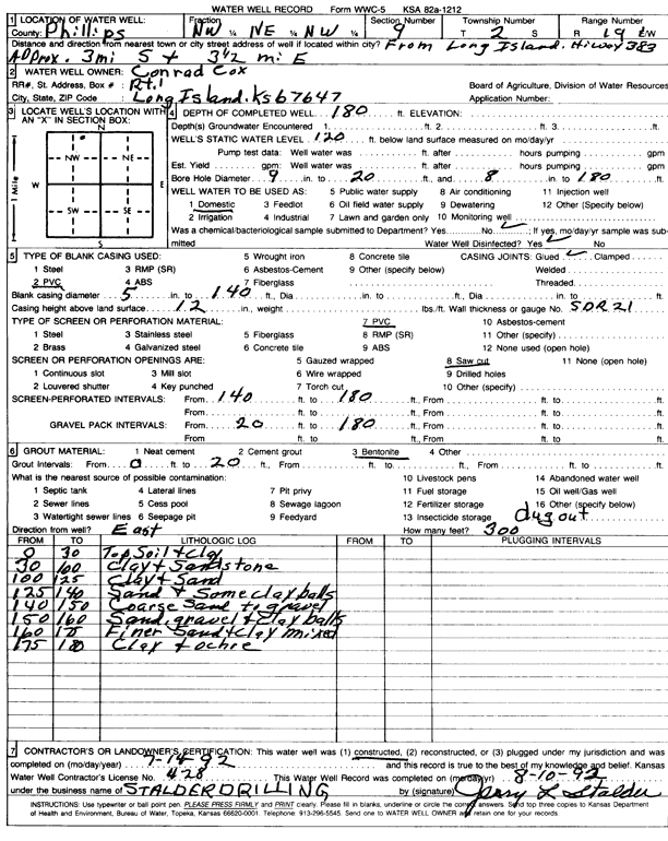
Specific Water Well Detail |
|
|
| Location Info | |||
| Owner: Cox, Conrad | Status: Constructed | ||
| Location: T2S, R19W, Sec. 9, NW NE NW | County: Phillips | ||
| Directions: from Long Island, Hwy 383, 3 mi S and 3.5 mi E | |||
| Latitude: 39.8998138 | Longitude: -99.4719592 | Datum NAD 27 | |
| Latitude: 39.8998233 | Longitude: -99.4723398 | Datum NAD 83 | |
| Longitude and latitude calculated by Survey from township-range-section-quarter calls. Only good to within the quarter call accuracy. | |||
| View well on interactive map | |||
| General Info | ||
| Well Depth: 180 ft. | Elevation: ft. | |
| Static Water Level: 120 ft. | Est. Yield: gpm. | |
| Comp. Date: 14-Jul-1992 | Well Use: Domestic | |
| DWR Applic. #: | Other ID: | |
| Driller Info | ||
| Driller: Leo J. Stalder Drilling | License #: 428 | |
| Scanned Form | View scan |
|
Chemical Sample Submitted?: No
Water Well disinfected?: | ||
| Ground water encountered: 0 ft. , 0 ft. , 0 ft. | ||
| Pump test data: Well water was 0 ft after 0 hours pumping 0 gpm | ||
| Casing Info | ||
| Casing Type: PVC
Casing Joints: |
Diam: 5 in. to 140 ft
Diam: 0 in. to 0 ft Diam: 0 in. to 0 ft | |
| Casing height above land surface: in
Casing Weight: lbs/ft Wall thickness or gauge no.: | ||
| Screen and Perforation Info | ||
| Screen Type: PVC | Screen Openings: Saw cut | |
| Screen-perforated intervals | From: 140 ft to 180 ft
From: 0 ft to 0 ft From: 0 ft to 0 ft | |
| Gravel pack intervals | From: ft to ft | |
| Grout Info | ||
| Grout used: Bentonite | From: 0 to 20 ft
From: 0 to 0 ft From: 0 to 0 ft | |
| Source of Possible Contamination | ||
| Source: OTHER | ||
| Direction from well: | Distance: 0 ft | |
| Lithologic Log
(Log data entered by KGS.) | ||
| From: 0 ft. to 30 ft. | topsoil and clay | |
| From: 30 ft. to 100 ft. | clay and sandstone | |
| From: 100 ft. to 125 ft. | clay and sand | |
| From: 125 ft. to 140 ft. | sand and some clay balls | |
| From: 140 ft. to 150 ft. | coarse sand to gravel | |
| From: 150 ft. to 160 ft. | sand, gravel, and clay balls | |
| From: 160 ft. to 175 ft. | finer sand and clay mixed | |
| From: 175 ft. to 180 ft. | clay and ochre | |