|
|
|
Specific Water Well Detail |
|
|
| Location Info | |||
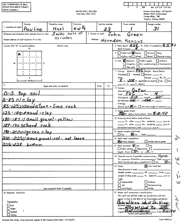
| Owner: Green, John | Status: Constructed | ||
| Location: T1S, R31W, Sec. 21, NW NW NW | County: Rawlins | ||
| Directions: from Herndon, 3 mi N | |||
| Latitude: 39.9577798 | Longitude: -100.8125962 | Datum NAD 27 | |
| Latitude: 39.9577831 | Longitude: -100.8130278 | Datum NAD 83 | |
| Longitude and latitude calculated by Survey from township-range-section-quarter calls. Only good to within the quarter call accuracy. | |||
| View well on interactive map | |||
| General Info | ||
| Well Depth: 228 ft. | Elevation: ft. | |
| Static Water Level: 196 ft. | Est. Yield: gpm. | |
| Comp. Date: 03-May-1984 | Well Use: Domestic | |
| DWR Applic. #: | Other ID: | |
| Driller Info | ||
| Driller: Bob Wilcox Well Dilling | License #: 286 | |
| Scanned Form | View scan |
|
Chemical Sample Submitted?:
Water Well disinfected?: | ||
| Ground water encountered: 0 ft. , 0 ft. , 0 ft. | ||
| Pump test data: Well water was 0 ft after 0 hours pumping 0 gpm | ||
| Casing Info | ||
| Casing Type: PVC
Casing Joints: |
Diam: 4 in. to 228 ft
Diam: 0 in. to 0 ft Diam: 0 in. to 0 ft | |
| Casing height above land surface: in
Casing Weight: lbs/ft Wall thickness or gauge no.: | ||
| Screen and Perforation Info | ||
| Screen Type: PVC | Screen Openings: Mill slot | |
| Screen-perforated intervals | From: 114 ft to 124 ft
From: 0 ft to 0 ft From: 0 ft to 0 ft | |
| Gravel pack intervals | From: ft to ft | |
| Grout Info | ||
| Grout used: Neat cement | From: 0 to 0 ft
From: 0 to 0 ft From: 0 to 0 ft | |
| Source of Possible Contamination | ||
| Source: Fertilizer storage | ||
| Direction from well: | Distance: 0 ft | |
| Lithologic Log
(Log data entered by KGS.) | ||
| From: 0 ft. to 5 ft. | top soil | |
| From: 5 ft. to 85 ft. | clay | |
| From: 85 ft. to 125 ft. | sandstone, lime rock | |
| From: 125 ft. to 180 ft. | sand, clay | |
| From: 180 ft. to 187 ft. | small gravel, yellow | |
| From: 187 ft. to 190 ft. | hard rock | |
| From: 190 ft. to 205 ft. | green clay | |
| From: 205 ft. to 225 ft. | small gravel, red, not loose | |
| From: 225 ft. to 228 ft. | bottom | |