|
|
|
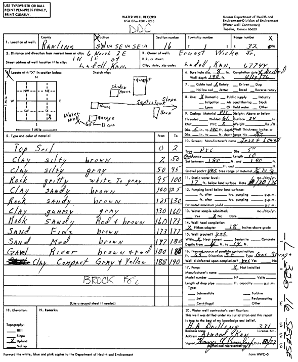
Specific Water Well Detail |
|
|
| Location Info | |||
| Owner: Wicke, Ernest | Status: Constructed | ||
| Location: T1S, R32W, Sec. 16, SE SE SE | County: Rawlins | ||
| Directions: from Ludell, 6 mi N, 2 mi E, 1 mi N, and 1 mi E | |||
| Latitude: 39.9595868 | Longitude: -100.9078246 | Datum NAD 27 | |
| Latitude: 39.9595896 | Longitude: -100.9082584 | Datum NAD 83 | |
| Longitude and latitude calculated by Survey from township-range-section-quarter calls. Only good to within the quarter call accuracy. | |||
| View well on interactive map | |||
| General Info | ||
| Well Depth: 190 ft. | Elevation: ft. | |
| Static Water Level: 17 ft. | Est. Yield: gpm. | |
| Comp. Date: 14-Apr-1976 | Well Use: Domestic | |
| DWR Applic. #: | Other ID: | |
| Driller Info | ||
| Driller: H.A. Bearley Drilling | License #: 331 | |
| Scanned Form | View scan |
|
Chemical Sample Submitted?: No
Water Well disinfected?: | ||
| Ground water encountered: 0 ft. , 0 ft. , 0 ft. | ||
| Pump test data: Well water was 0 ft after 0 hours pumping 0 gpm | ||
| Casing Info | ||
| Casing Type:
Casing Joints: |
Diam: 0 in. to 0 ft
Diam: 0 in. to 0 ft Diam: 0 in. to 0 ft | |
| Casing height above land surface: in
Casing Weight: lbs/ft Wall thickness or gauge no.: | ||
| Screen and Perforation Info | ||
| Screen Type: | Screen Openings: | |
| Screen-perforated intervals | From: 180 ft to 190 ft
From: 0 ft to 0 ft From: 0 ft to 0 ft | |
| Gravel pack intervals | From: ft to ft | |
| Grout Info | ||
| Grout used: | From: 0 to 0 ft
From: 0 to 0 ft From: 0 to 0 ft | |
| Source of Possible Contamination | ||
| Source: | ||
| Direction from well: | Distance: 0 ft | |
| Lithologic Log
(Log data entered by KGS.) | ||
| From: 0 ft. to 2 ft. | top soil | |
| From: 2 ft. to 50 ft. | clay, silty, brown | |
| From: 50 ft. to 95 ft. | clay, silty, gravel | |
| From: 95 ft. to 100 ft. | rock, gritty, white to gray | |
| From: 100 ft. to 125 ft. | clay, sandy, brown | |
| From: 125 ft. to 130 ft. | rock, sandy, brown | |
| From: 130 ft. to 160 ft. | clay, gummy, gray | |
| From: 160 ft. to 173 ft. | rock, sandy, red and brown | |
| From: 173 ft. to 177 ft. | sand, fine, brown | |
| From: 177 ft. to 180 ft. | sand, medium, brown | |
| From: 180 ft. to 188 ft. | gravel, river, brown and red | |
| From: 188 ft. to 190 ft. | clay, compact, gray and yellow | |