|
|
|
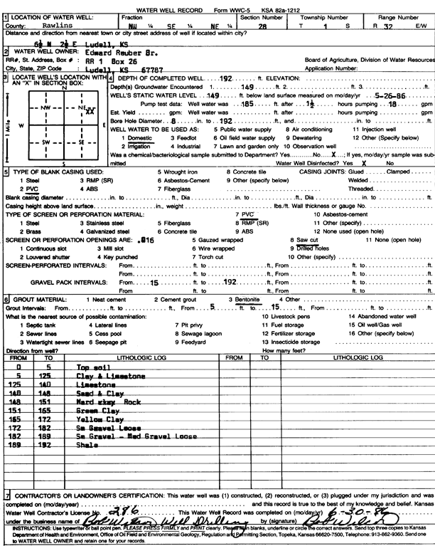
Specific Water Well Detail |
|
|
| Location Info | |||
| Owner: Reuber, Edward | Status: Constructed | ||
| Location: T1S, R32W, Sec. 28, NW SE NE | County: Rawlins | ||
| Directions: from Ludell, 6.5 mi N and 2.5 mi E | |||
| Latitude: 39.9396934 | Longitude: -100.9101459 | Datum NAD 27 | |
| Latitude: 39.9396962 | Longitude: -100.9105796 | Datum NAD 83 | |
| Longitude and latitude calculated by Survey from township-range-section-quarter calls. Only good to within the quarter call accuracy. | |||
| View well on interactive map | |||
| General Info | ||
| Well Depth: 192 ft. | Elevation: ft. | |
| Static Water Level: 149 ft. | Est. Yield: gpm. | |
| Comp. Date: 30-Jun-1986 | Well Use: Domestic | |
| DWR Applic. #: | Other ID: | |
| Driller Info | ||
| Driller: Bob Wilcox Well Dilling | License #: 286 | |
| Scanned Form | View scan |
|
Chemical Sample Submitted?: No
Water Well disinfected?: | ||
| Ground water encountered: 149 ft. , 0 ft. , 0 ft. | ||
| Pump test data: Well water was 185 ft after 1 hours pumping 18 gpm | ||
| Casing Info | ||
| Casing Type: PVC
Casing Joints: |
Diam: 0 in. to 0 ft
Diam: 0 in. to 0 ft Diam: 0 in. to 0 ft | |
| Casing height above land surface: in
Casing Weight: lbs/ft Wall thickness or gauge no.: | ||
| Screen and Perforation Info | ||
| Screen Type: PVC | Screen Openings: Saw cut | |
| Screen-perforated intervals | From: 0 ft to 0 ft
From: 0 ft to 0 ft From: 0 ft to 0 ft | |
| Gravel pack intervals | From: ft to ft | |
| Grout Info | ||
| Grout used: Bentonite | From: 0 to 0 ft
From: 5 to 15 ft From: 0 to 0 ft | |
| Source of Possible Contamination | ||
| Source: | ||
| Direction from well: | Distance: 0 ft | |
| Lithologic Log
(Log data entered by KGS.) | ||
| From: 0 ft. to 5 ft. | top soil | |
| From: 5 ft. to 125 ft. | clay and limestone | |
| From: 125 ft. to 140 ft. | limestone | |
| From: 140 ft. to 148 ft. | sand and clay | |
| From: 148 ft. to 151 ft. | hard rock | |
| From: 151 ft. to 165 ft. | green clay | |
| From: 165 ft. to 172 ft. | yellow clay | |
| From: 172 ft. to 182 ft. | small gravel, loose | |
| From: 182 ft. to 189 ft. | small gravel, medium gravel, loose | |
| From: 189 ft. to 192 ft. | shale | |