|
|
|
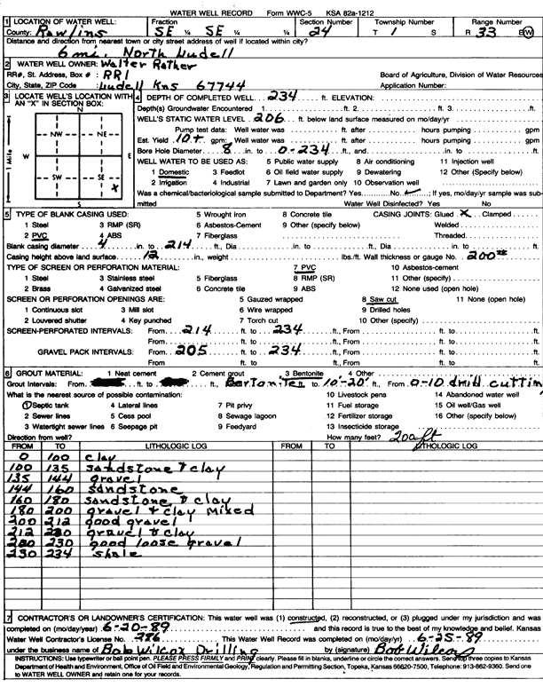
Specific Water Well Detail |
|
|
| Location Info | |||
| Owner: Rather, Walter | Status: Constructed | ||
| Location: T1S, R33W, Sec. 24, SE SE | County: Rawlins | ||
| Directions: from Ludell, 6 mi N | |||
| Latitude: 39.9461769 | Longitude: -100.9643462 | Datum NAD 27 | |
| Latitude: 39.9461793 | Longitude: -100.964781 | Datum NAD 83 | |
| Longitude and latitude calculated by Survey from township-range-section-quarter calls. Only good to within the quarter call accuracy. | |||
| View well on interactive map | |||
| General Info | ||
| Well Depth: 234 ft. | Elevation: ft. | |
| Static Water Level: 206 ft. | Est. Yield: 10 gpm. | |
| Comp. Date: 20-Jun-1989 | Well Use: Domestic | |
| DWR Applic. #: | Other ID: | |
| Driller Info | ||
| Driller: Bob Wilcox Well Dilling | License #: 286 | |
| Scanned Form | View scan |
|
Chemical Sample Submitted?: No
Water Well disinfected?: | ||
| Ground water encountered: 0 ft. , 0 ft. , 0 ft. | ||
| Pump test data: Well water was 0 ft after 0 hours pumping 0 gpm | ||
| Casing Info | ||
| Casing Type: PVC
Casing Joints: |
Diam: 4 in. to 214 ft
Diam: 0 in. to 0 ft Diam: 0 in. to 0 ft | |
| Casing height above land surface: in
Casing Weight: lbs/ft Wall thickness or gauge no.: | ||
| Screen and Perforation Info | ||
| Screen Type: PVC | Screen Openings: Saw cut | |
| Screen-perforated intervals | From: 214 ft to 234 ft
From: 0 ft to 0 ft From: 0 ft to 0 ft | |
| Gravel pack intervals | From: ft to ft | |
| Grout Info | ||
| Grout used: Bentonite | From: 10 to 20 ft
From: 0 to 10 ft From: 0 to 0 ft | |
| Source of Possible Contamination | ||
| Source: Septic Tank | ||
| Direction from well: | Distance: 0 ft | |
| Lithologic Log
(Log data entered by KGS.) | ||
| From: 0 ft. to 100 ft. | clay | |
| From: 100 ft. to 135 ft. | sandstone and clay | |
| From: 135 ft. to 144 ft. | gravel | |
| From: 144 ft. to 160 ft. | sandstone | |
| From: 160 ft. to 180 ft. | sandstone and clay | |
| From: 180 ft. to 200 ft. | gravel and clay mixed | |
| From: 200 ft. to 212 ft. | good gravel | |
| From: 212 ft. to 220 ft. | gravel and clay | |
| From: 220 ft. to 230 ft. | good loose gravel | |
| From: 230 ft. to 234 ft. | shale | |