|
|
|
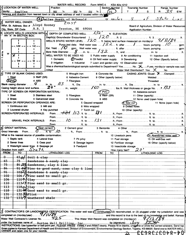
Specific Water Well Detail |
|
|
| Location Info | |||
| Owner: Rooney, Lloyd | Status: Constructed | ||
| Location: T1S, R35W, Sec. 24, NW NW SW | County: Rawlins | ||
| Directions: from McDonald, 18 mi NE | |||
| Latitude: 39.9503559 | Longitude: -101.2037101 | Datum NAD 27 | |
| Latitude: 39.9503549 | Longitude: -101.2041481 | Datum NAD 83 | |
| Longitude and latitude calculated by Survey from township-range-section-quarter calls. Only good to within the quarter call accuracy. | |||
| View well on interactive map | |||
| General Info | ||
| Well Depth: 132 ft. | Elevation: ft. | |
| Static Water Level: 120 ft. | Est. Yield: 10 gpm. | |
| Comp. Date: 11-Sep-1984 | Well Use: Domestic, Livestock | |
| DWR Applic. #: | Other ID: | |
| Driller Info | ||
| Driller: Burton Well Drilling, Inc. | License #: 425 | |
| Scanned Form | View scan |
|
Chemical Sample Submitted?: No
Water Well disinfected?: | ||
| Ground water encountered: 120 ft. , 0 ft. , 0 ft. | ||
| Pump test data: Well water was 122 ft after 0 hours pumping 0 gpm | ||
| Casing Info | ||
| Casing Type: PVC
Casing Joints: |
Diam: 4 in. to 113 ft
Diam: 0 in. to 0 ft Diam: 0 in. to 0 ft | |
| Casing height above land surface: in
Casing Weight: lbs/ft Wall thickness or gauge no.: | ||
| Screen and Perforation Info | ||
| Screen Type: PVC | Screen Openings: Saw cut | |
| Screen-perforated intervals | From: 113 ft to 131 ft
From: 0 ft to 0 ft From: 0 ft to 0 ft | |
| Gravel pack intervals | From: ft to ft | |
| Grout Info | ||
| Grout used: Neat cement | From: 0 to 10 ft
From: 0 to 0 ft From: 0 to 0 ft | |
| Source of Possible Contamination | ||
| Source: Abandoned water well | ||
| Direction from well: | Distance: 0 ft | |
| Lithologic Log
(Log data entered by KGS.) | ||
| From: 0 ft. to 65 ft. | soil and clay | |
| From: 65 ft. to 75 ft. | sandstone and sandy clay | |
| From: 75 ft. to 84 ft. | sandstone, clay and lime | |
| From: 84 ft. to 91 ft. | fine to good sand, some clay and lime | |
| From: 91 ft. to 102 ft. | sandstone and sandy clay | |
| From: 102 ft. to 106 ft. | fine sand to small gravel | |
| From: 106 ft. to 110 ft. | clay | |
| From: 110 ft. to 113 ft. | fine sand to small gravel | |
| From: 113 ft. to 118 ft. | clay | |
| From: 118 ft. to 131 ft. | good sand to small gravel | |
| From: 131 ft. to 132 ft. | flint | |
| From: 132 ft. to 137 ft. | weathered shale | |