|
|
|
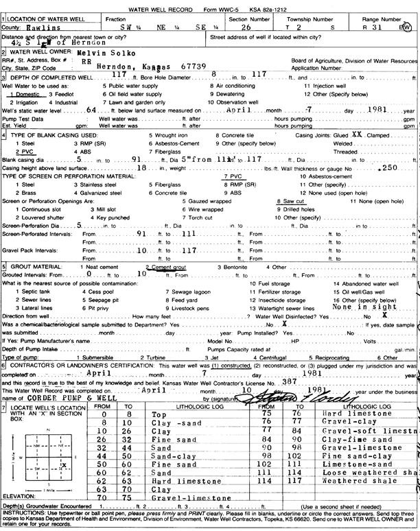
Specific Water Well Detail |
|
|
| Location Info | |||
| Owner: Solko, Melvin | Status: Constructed | ||
| Location: T2S, R31W, Sec. 26, SW NE SE | County: Rawlins | ||
| Directions: from Herndon, 4.5 mi S and 1 mi E | |||
| Latitude: 39.8474397 | Longitude: -100.7621586 | Datum NAD 27 | |
| Latitude: 39.8474435 | Longitude: -100.7625876 | Datum NAD 83 | |
| Longitude and latitude calculated by Survey from township-range-section-quarter calls. Only good to within the quarter call accuracy. | |||
| View well on interactive map | |||
| General Info | ||
| Well Depth: 117 ft. | Elevation: ft. | |
| Static Water Level: 64 ft. | Est. Yield: gpm. | |
| Comp. Date: 07-Apr-1981 | Well Use: Domestic | |
| DWR Applic. #: | Other ID: | |
| Driller Info | ||
| Driller: Stephen E. Corder Pump & Well | License #: 387 | |
| Scanned Form | View scan |
|
Chemical Sample Submitted?: No
Water Well disinfected?: | ||
| Ground water encountered: 0 ft. , 0 ft. , 0 ft. | ||
| Pump test data: Well water was 0 ft after 0 hours pumping 0 gpm | ||
| Casing Info | ||
| Casing Type:
Casing Joints: |
Diam: 0 in. to 0 ft
Diam: 0 in. to 0 ft Diam: 0 in. to 0 ft | |
| Casing height above land surface: in
Casing Weight: lbs/ft Wall thickness or gauge no.: | ||
| Screen and Perforation Info | ||
| Screen Type: | Screen Openings: | |
| Screen-perforated intervals | From: 91 ft to 111 ft
From: 0 ft to 0 ft From: 0 ft to 0 ft | |
| Gravel pack intervals | From: ft to ft | |
| Grout Info | ||
| Grout used: | From: 0 to 0 ft
From: 0 to 0 ft From: 0 to 0 ft | |
| Source of Possible Contamination | ||
| Source: | ||
| Direction from well: | Distance: 0 ft | |
| Lithologic Log
(Log data entered by KGS.) | ||
| From: 0 ft. to 8 ft. | top | |
| From: 8 ft. to 10 ft. | clay, sand | |
| From: 10 ft. to 26 ft. | clay | |
| From: 26 ft. to 32 ft. | fine sand | |
| From: 32 ft. to 44 ft. | sand | |
| From: 44 ft. to 50 ft. | sand, clay | |
| From: 50 ft. to 60 ft. | fine sand | |
| From: 60 ft. to 62 ft. | sand | |
| From: 62 ft. to 63 ft. | hard limestone | |
| From: 63 ft. to 70 ft. | clay | |
| From: 70 ft. to 75 ft. | gravel, limestone | |
| From: 75 ft. to 76 ft. | hard limestone | |
| From: 76 ft. to 77 ft. | gravel, clay | |
| From: 77 ft. to 84 ft. | gravel, soft limestone | |
| From: 84 ft. to 90 ft. | clay, fine sand | |
| From: 90 ft. to 98 ft. | gravel, limestone | |
| From: 98 ft. to 102 ft. | fine sand, clay | |
| From: 102 ft. to 111 ft. | limestone, sand | |
| From: 111 ft. to 114 ft. | loose weathered shale | |
| From: 114 ft. to 117 ft. | weathered shale | |