|
|
|
Specific Water Well Detail |
|
|
| Location Info | |||
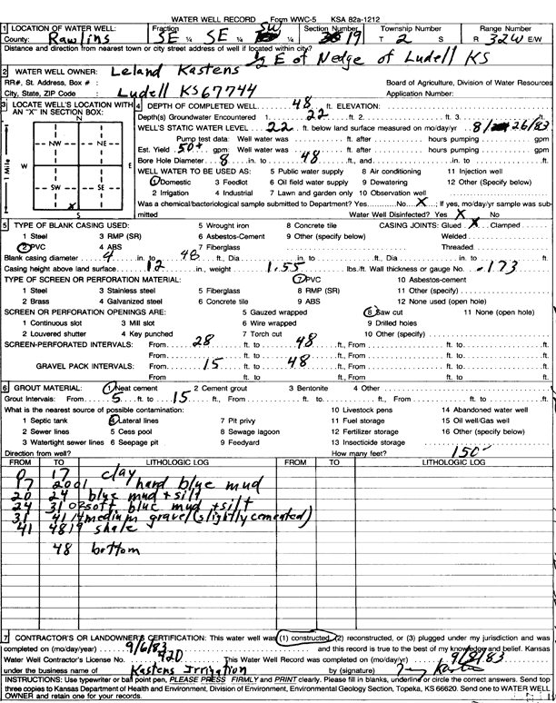
| Owner: Kastens, Leland | Status: Constructed | ||
| Location: T2S, R32W, Sec. 19, SE SE SW | County: Rawlins | ||
| Directions: from Ludell, 0.5 mi E | |||
| Latitude: 39.8583195 | Longitude: -100.9543301 | Datum NAD 27 | |
| Latitude: 39.8583219 | Longitude: -100.9547637 | Datum NAD 83 | |
| Longitude and latitude calculated by Survey from township-range-section-quarter calls. Only good to within the quarter call accuracy. | |||
| View well on interactive map | |||
| General Info | ||
| Well Depth: 48 ft. | Elevation: ft. | |
| Static Water Level: 22 ft. | Est. Yield: 50 gpm. | |
| Comp. Date: 06-Sep-1983 | Well Use: Domestic | |
| DWR Applic. #: | Other ID: | |
| Driller Info | ||
| Driller: Terry Kastens Irrigation | License #: 420 | |
| Scanned Form | View scan |
|
Chemical Sample Submitted?: No
Water Well disinfected?: | ||
| Ground water encountered: 0 ft. , 0 ft. , 0 ft. | ||
| Pump test data: Well water was 0 ft after 0 hours pumping 0 gpm | ||
| Casing Info | ||
| Casing Type:
Casing Joints: |
Diam: 0 in. to 0 ft
Diam: 0 in. to 0 ft Diam: 0 in. to 0 ft | |
| Casing height above land surface: in
Casing Weight: lbs/ft Wall thickness or gauge no.: | ||
| Screen and Perforation Info | ||
| Screen Type: | Screen Openings: | |
| Screen-perforated intervals | From: 28 ft to 48 ft
From: 0 ft to 0 ft From: 0 ft to 0 ft | |
| Gravel pack intervals | From: ft to ft | |
| Grout Info | ||
| Grout used: | From: 0 to 0 ft
From: 0 to 0 ft From: 0 to 0 ft | |
| Source of Possible Contamination | ||
| Source: | ||
| Direction from well: | Distance: 0 ft | |
| Lithologic Log
(Log data entered by KGS.) | ||
| From: 0 ft. to 17 ft. | clay | |
| From: 17 ft. to 20 ft. | hard blue mud | |
| From: 20 ft. to 24 ft. | blue mud and silt | |
| From: 24 ft. to 31 ft. | soft blue mud and silt | |
| From: 31 ft. to 41 ft. | medium gravel, slightly cemented | |
| From: 41 ft. to 48 ft. | shale | |