|
|
|
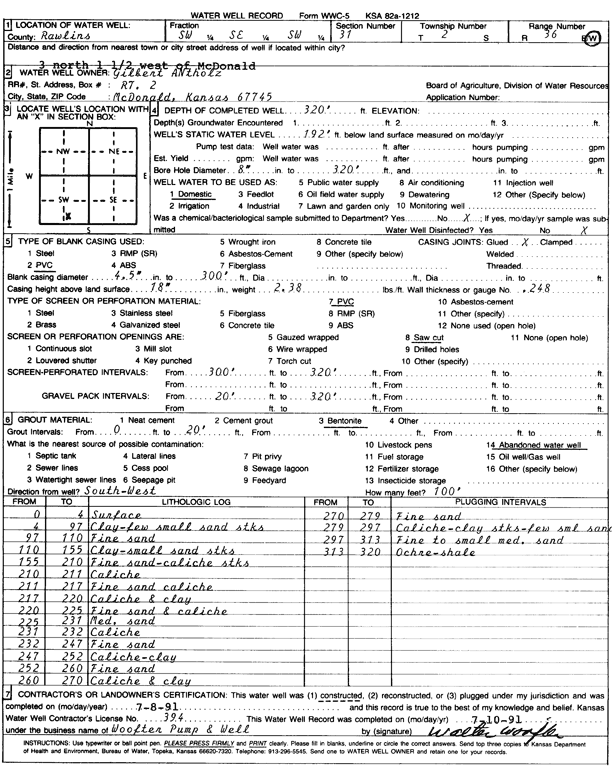
Specific Water Well Detail |
|
|
| Location Info | |||
| Owner: Antholz, Gilbert | Status: Constructed | ||
| Location: T2S, R36W, Sec. 31, SW SE SW | County: Rawlins | ||
| Directions: from McDonald, 3 mi N and 1.5 mi W | |||
| Latitude: 39.830276 | Longitude: -101.4035126 | Datum NAD 27 | |
| Latitude: 39.8302727 | Longitude: -101.4039536 | Datum NAD 83 | |
| Longitude and latitude calculated by Survey from township-range-section-quarter calls. Only good to within the quarter call accuracy. | |||
| View well on interactive map | |||
| General Info | ||
| Well Depth: 320 ft. | Elevation: ft. | |
| Static Water Level: 192 ft. | Est. Yield: gpm. | |
| Comp. Date: 08-Jul-1991 | Well Use: Domestic | |
| DWR Applic. #: | Other ID: | |
| Driller Info | ||
| Driller: Walter Woofter Pump & Well | License #: 394 | |
| Scanned Form | View scan |
|
Chemical Sample Submitted?: No
Water Well disinfected?: | ||
| Ground water encountered: 0 ft. , 0 ft. , 0 ft. | ||
| Pump test data: Well water was 0 ft after 0 hours pumping 0 gpm | ||
| Casing Info | ||
| Casing Type: PVC
Casing Joints: |
Diam: 4 in. to 300 ft
Diam: 0 in. to 0 ft Diam: 0 in. to 0 ft | |
| Casing height above land surface: in
Casing Weight: lbs/ft Wall thickness or gauge no.: | ||
| Screen and Perforation Info | ||
| Screen Type: PVC | Screen Openings: Saw cut | |
| Screen-perforated intervals | From: 300 ft to 320 ft
From: 0 ft to 0 ft From: 0 ft to 0 ft | |
| Gravel pack intervals | From: ft to ft | |
| Grout Info | ||
| Grout used: Bentonite | From: 0 to 20 ft
From: 0 to 0 ft From: 0 to 0 ft | |
| Source of Possible Contamination | ||
| Source: Abandoned water well | ||
| Direction from well: | Distance: 0 ft | |
| Lithologic Log
(Log data entered by KGS.) | ||
| From: 0 ft. to 4 ft. | surface | |
| From: 4 ft. to 97 ft. | clay, few small sand streaks | |
| From: 97 ft. to 110 ft. | fine sand | |
| From: 110 ft. to 155 ft. | clay, small sand streaks | |
| From: 155 ft. to 210 ft. | fine sand, caliche streaks | |
| From: 210 ft. to 211 ft. | caliche | |
| From: 211 ft. to 217 ft. | fine sand, caliche | |
| From: 217 ft. to 220 ft. | caliche and clay | |
| From: 220 ft. to 225 ft. | fine sand and caliche | |
| From: 225 ft. to 231 ft. | medium sand | |
| From: 231 ft. to 232 ft. | caliche | |
| From: 232 ft. to 247 ft. | fine sand | |
| From: 247 ft. to 252 ft. | caliche, clay | |
| From: 252 ft. to 260 ft. | fine sand | |
| From: 260 ft. to 270 ft. | caliche and clay | |
| From: 270 ft. to 279 ft. | fine sand | |
| From: 279 ft. to 297 ft. | caliche, clay streaks, few small sand | |
| From: 297 ft. to 313 ft. | fine to small medium sand | |
| From: 313 ft. to 320 ft. | ochre, shale | |