|
|
|
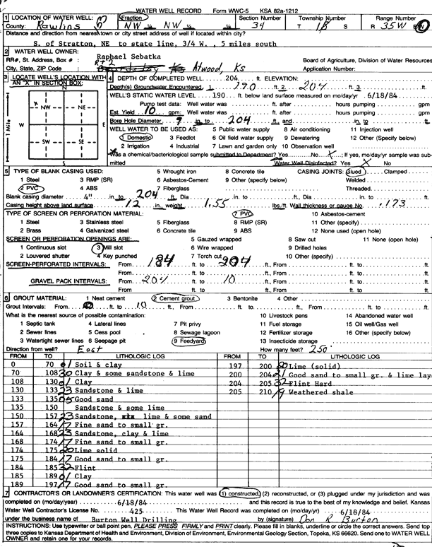
Specific Water Well Detail |
|
|
| Location Info | |||
| Owner: Sebatka, Raphael | Status: Constructed | ||
| Location: T1S, R35W, Sec. 34, NW NW | County: Rawlins | ||
| Directions: S of Stratton, Nebraska, to State Line, 0.75 mi W and 5 mi S | |||
| Latitude: 39.927856 | Longitude: -101.2397462 | Datum NAD 27 | |
| Latitude: 39.9278545 | Longitude: -101.2401846 | Datum NAD 83 | |
| Longitude and latitude calculated by Survey from township-range-section-quarter calls. Only good to within the quarter call accuracy. | |||
| View well on interactive map | |||
| General Info | ||
| Well Depth: 204 ft. | Elevation: ft. | |
| Static Water Level: 190 ft. | Est. Yield: 10 gpm. | |
| Comp. Date: 18-Jun-1984 | Well Use: Domestic | |
| DWR Applic. #: | Other ID: | |
| Driller Info | ||
| Driller: Burton Well Drilling, Inc. | License #: 425 | |
| Scanned Form | View scan |
|
Chemical Sample Submitted?: No
Water Well disinfected?: | ||
| Ground water encountered: 190 ft. , 204 ft. , 0 ft. | ||
| Pump test data: Well water was 0 ft after 0 hours pumping 0 gpm | ||
| Casing Info | ||
| Casing Type: PVC
Casing Joints: |
Diam: 4 in. to 204 ft
Diam: 0 in. to 0 ft Diam: 0 in. to 0 ft | |
| Casing height above land surface: in
Casing Weight: lbs/ft Wall thickness or gauge no.: | ||
| Screen and Perforation Info | ||
| Screen Type: PVC | Screen Openings: Mill slot | |
| Screen-perforated intervals | From: 184 ft to 204 ft
From: 0 ft to 0 ft From: 0 ft to 0 ft | |
| Gravel pack intervals | From: ft to ft | |
| Grout Info | ||
| Grout used: Cement grout | From: 0 to 10 ft
From: 0 to 0 ft From: 0 to 0 ft | |
| Source of Possible Contamination | ||
| Source: Feedyard | ||
| Direction from well: | Distance: 0 ft | |
| Lithologic Log
(Log data entered by KGS.) | ||
| From: 0 ft. to 70 ft. | soil and clay | |
| From: 70 ft. to 108 ft. | clay and some sandstone and lime | |
| From: 108 ft. to 130 ft. | clay | |
| From: 130 ft. to 133 ft. | sandstone and lime | |
| From: 133 ft. to 135 ft. | good sand | |
| From: 135 ft. to 150 ft. | sandstone and some lime | |
| From: 150 ft. to 157 ft. | sandstone, lime, and some sand | |
| From: 157 ft. to 164 ft. | fine sand to small gravel | |
| From: 164 ft. to 168 ft. | sandstone, clay and lime | |
| From: 168 ft. to 174 ft. | fine sand to small gravel | |
| From: 174 ft. to 184 ft. | good sand to small gravel | |
| From: 184 ft. to 185 ft. | flint | |
| From: 185 ft. to 189 ft. | clay | |
| From: 189 ft. to 197 ft. | good sand to small gravel | |
| From: 197 ft. to 200 ft. | lime, solid | |
| From: 200 ft. to 204 ft. | good sand to small gravel and lime layers | |
| From: 204 ft. to 205 ft. | flint, hard | |
| From: 205 ft. to 210 ft. | weathered shale | |