|
|
|
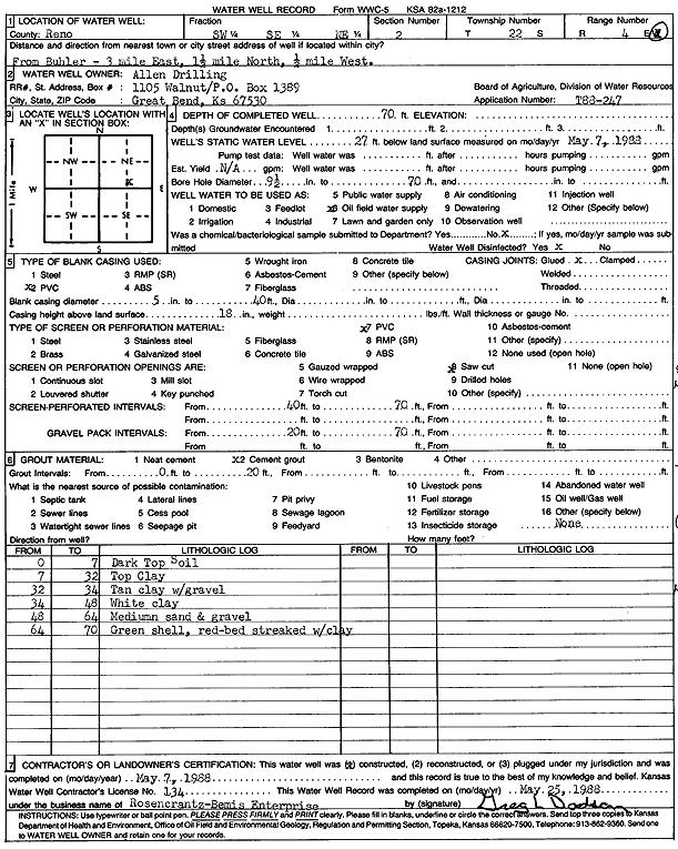
Specific Water Well Detail |
|
|
| Location Info | |||
| Owner: Allen Drilling Co. | Status: Constructed | ||
| Location: T22S, R4W, Sec. 2, SW SE NE | County: Reno | ||
| Directions: from Buhler: 3 mi E, 1.5 mi N, .5 mi W | |||
| Latitude: 38.1674601 | Longitude: -97.7234045 | Datum NAD 27 | |
| Latitude: 38.16747 | Longitude: -97.7237287 | Datum NAD 83 | |
| Longitude and latitude calculated by Survey from township-range-section-quarter calls. Only good to within the quarter call accuracy. | |||
| View well on interactive map | |||
| General Info | ||
| Well Depth: 70 ft. | Elevation: ft. | |
| Static Water Level: 27 ft. | Est. Yield: gpm. | |
| Comp. Date: 07-May-1988 | Well Use: Oil Field Water Supply | |
| DWR Applic. #: T88-247 | Other ID: | |
| Links | |
| No Wizard information available. | |
| View info from WIMAS Water Right Data base... | |
| Driller Info | ||
| Driller: Rosencrantz-Bemis Enterprises, Inc. | License #: 134 | |
| Scanned Form | View scan |
|
Chemical Sample Submitted?: No
Water Well disinfected?: | ||
| Ground water encountered: 0 ft. , 0 ft. , 0 ft. | ||
| Pump test data: Well water was 0 ft after 0 hours pumping 0 gpm | ||
| Casing Info | ||
| Casing Type: PVC
Casing Joints: |
Diam: 5 in. to 40 ft
Diam: 0 in. to 0 ft Diam: 0 in. to 0 ft | |
| Casing height above land surface: in
Casing Weight: lbs/ft Wall thickness or gauge no.: | ||
| Screen and Perforation Info | ||
| Screen Type: PVC | Screen Openings: Saw cut | |
| Screen-perforated intervals | From: 40 ft to 70 ft
From: 0 ft to 0 ft From: 0 ft to 0 ft | |
| Gravel pack intervals | From: ft to ft | |
| Grout Info | ||
| Grout used: Cement grout | From: 0 to 20 ft
From: 0 to 0 ft From: 0 to 0 ft | |
| Source of Possible Contamination | ||
| Source: | ||
| Direction from well: | Distance: 0 ft | |
| Lithologic Log
(Log data entered by KGS.) | ||
| From: 0 ft. to 7 ft. | dark top soil | |
| From: 7 ft. to 32 ft. | top clay | |
| From: 32 ft. to 34 ft. | tan clay with gravel | |
| From: 34 ft. to 48 ft. | white clay | |
| From: 48 ft. to 64 ft. | medium sand and gravel | |
| From: 64 ft. to 70 ft. | green shale, red-bed streaked with clay | |