|
|
|
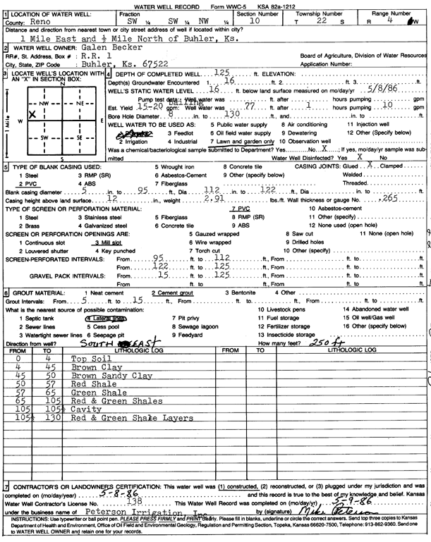
Specific Water Well Detail |
|
|
| Location Info | |||
| Owner: Becker, Galen | Status: Constructed | ||
| Location: T22S, R4W, Sec. 10, SW SW NW | County: Reno | ||
| Directions: from Buhler: 1 mi E, .5 mi N | |||
| Latitude: 38.1529642 | Longitude: -97.7559912 | Datum NAD 27 | |
| Latitude: 38.1529743 | Longitude: -97.7563165 | Datum NAD 83 | |
| Longitude and latitude calculated by Survey from township-range-section-quarter calls. Only good to within the quarter call accuracy. | |||
| View well on interactive map | |||
| General Info | ||
| Well Depth: 125 ft. | Elevation: ft. | |
| Static Water Level: 16 ft. | Est. Yield: 15 gpm. | |
| Comp. Date: 08-May-1986 | Well Use: Domestic, Lawn and Garden | |
| DWR Applic. #: | Other ID: | |
| Driller Info | ||
| Driller: Peterson Irrigation, Inc. | License #: 138 | |
| Scanned Form | View scan |
|
Chemical Sample Submitted?: No
Water Well disinfected?: | ||
| Ground water encountered: 16 ft. , 0 ft. , 0 ft. | ||
| Pump test data: Well water was 0 ft after 0 hours pumping 0 gpm | ||
| Casing Info | ||
| Casing Type: PVC
Casing Joints: |
Diam: 5 in. to 95 ft
Diam: 99 in. to 122 ft Diam: 0 in. to 0 ft | |
| Casing height above land surface: in
Casing Weight: lbs/ft Wall thickness or gauge no.: | ||
| Screen and Perforation Info | ||
| Screen Type: PVC | Screen Openings: Mill slot | |
| Screen-perforated intervals | From: 95 ft to 112 ft
From: 0 ft to 0 ft From: 122 ft to 125 ft | |
| Gravel pack intervals | From: ft to ft | |
| Grout Info | ||
| Grout used: Cement grout | From: 5 to 15 ft
From: 0 to 0 ft From: 0 to 0 ft | |
| Source of Possible Contamination | ||
| Source: Lateral lines | ||
| Direction from well: | Distance: 0 ft | |
| Lithologic Log
(Log data entered by KGS.) | ||
| From: 0 ft. to 4 ft. | top soil | |
| From: 4 ft. to 45 ft. | brown clay | |
| From: 45 ft. to 50 ft. | brown sandy clay | |
| From: 50 ft. to 57 ft. | red shale | |
| From: 57 ft. to 65 ft. | green shale | |
| From: 65 ft. to 105 ft. | red and green shale | |
| From: 105 ft. to 105.5 ft. | cavity | |
| From: 105.5 ft. to 130 ft. | red and green shale layers | |