|
|
|
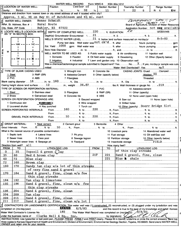
Specific Water Well Detail |
|
|
| Location Info | |||
| Owner: Schmidt, Menno | Status: Constructed | ||
| Location: T22S, R4W, Sec. 11, C SE | County: Reno | ||
| Directions: from Hutchinson: 5 mi NE on Hwy 61, 6.4 mi E | |||
| Latitude: 38.1484193 | Longitude: -97.7246692 | Datum NAD 27 | |
| Latitude: 38.1484293 | Longitude: -97.7249935 | Datum NAD 83 | |
| Longitude and latitude calculated by Survey from township-range-section-quarter calls. Only good to within the quarter call accuracy. | |||
| View well on interactive map | |||
| General Info | ||
| Well Depth: 220 ft. | Elevation: ft. | |
| Static Water Level: 21 ft. | Est. Yield: 1000 gpm. | |
| Comp. Date: 05-Aug-1983 | Well Use: Irrigation | |
| DWR Applic. #: | Other ID: | |
| Links | |
| No Wizard information available. | |
| View info from WIMAS Water Right Data base... | |
| Driller Info | ||
| Driller: Clarke Well and Equipment, Inc. | License #: 185 | |
| Scanned Form | View scan |
|
Chemical Sample Submitted?: No
Water Well disinfected?: | ||
| Ground water encountered: 21 ft. , 0 ft. , 0 ft. | ||
| Pump test data: Well water was 0 ft after 0 hours pumping 0 gpm | ||
| Casing Info | ||
| Casing Type: Steel
Casing Joints: |
Diam: 16 in. to 160 ft
Diam: 0 in. to 0 ft Diam: 0 in. to 0 ft | |
| Casing height above land surface: in
Casing Weight: lbs/ft Wall thickness or gauge no.: | ||
| Screen and Perforation Info | ||
| Screen Type: Steel | Screen Openings: OTHER | |
| Screen-perforated intervals | From: 160 ft to 220 ft
From: 0 ft to 0 ft From: 0 ft to 0 ft | |
| Gravel pack intervals | From: ft to ft | |
| Grout Info | ||
| Grout used: Neat cement | From: 0 to 10 ft
From: 0 to 0 ft From: 0 to 0 ft | |
| Source of Possible Contamination | ||
| Source: OTHER | ||
| Direction from well: | Distance: 0 ft | |
| Lithologic Log
(Log data entered by KGS.) | ||
| From: 0 ft. to 35 ft. | top soil and green clay | |
| From: 35 ft. to 60 ft. | red and brown clay | |
| From: 60 ft. to 72 ft. | blue clay | |
| From: 72 ft. to 160 ft. | brown clay | |
| From: 160 ft. to 170 ft. | sandy tan clay with a lot of thin streaks of very fine sand and gravel | |
| From: 170 ft. to 184 ft. | sand and gravel, fine, clean, with a few thin clay streaks | |
| From: 184 ft. to 192 ft. | tan clay and limestone | |
| From: 192 ft. to 196 ft. | sand and gravel, fine, clean, with a few thin clay streaks | |
| From: 196 ft. to 204 ft. | sand and gravel, fine, clean | |
| From: 204 ft. to 209 ft. | tan clay | |
| From: 209 ft. to 211 ft. | sand and gravel, fine, clean | |
| From: 211 ft. to 217 ft. | sand and gravel, fine, clean, with a lot of thin clay streaks | |
| From: 217 ft. to 221 ft. | sand and gravel, fine, clean | |
| From: 221 ft. to ft. | blue shale | |