|
|
|
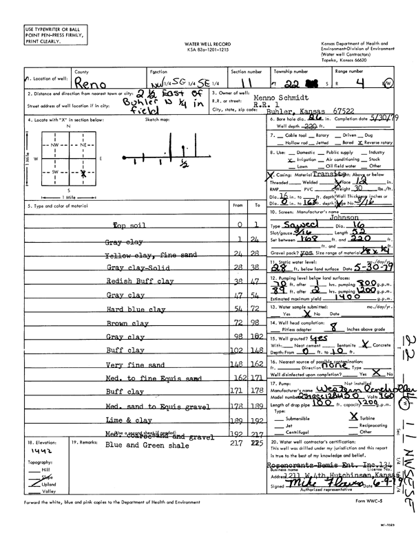
Specific Water Well Detail |
|
|
| Location Info | |||
| Owner: Schmidt, Menno | Status: Constructed | ||
| Location: T22S, R4W, Sec. 11, NW SE SE | County: Reno | ||
| Directions: from Buhler: 2.5 mi E, .25 mi N, into field | |||
| Latitude: 38.1474998 | Longitude: -97.7235161 | Datum NAD 27 | |
| Latitude: 38.1475099 | Longitude: -97.7238404 | Datum NAD 83 | |
| Longitude and latitude calculated by Survey from township-range-section-quarter calls. Only good to within the quarter call accuracy. | |||
| View well on interactive map | |||
| General Info | ||
| Well Depth: 220 ft. | Elevation: ft. | |
| Static Water Level: 28 ft. | Est. Yield: 1400 gpm. | |
| Comp. Date: 30-May-1979 | Well Use: Irrigation | |
| DWR Applic. #: | Other ID: | |
| Links | |
| No Wizard information available. | |
| View info from WIMAS Water Right Data base... | |
| Driller Info | ||
| Driller: Rosencrantz-Bemis Enterprises, Inc. | License #: 134 | |
| Scanned Form | View scan |
|
Chemical Sample Submitted?: No
Water Well disinfected?: | ||
| Ground water encountered: 0 ft. , 0 ft. , 0 ft. | ||
| Pump test data: Well water was 0 ft after 0 hours pumping 0 gpm | ||
| Casing Info | ||
| Casing Type:
Casing Joints: |
Diam: 0 in. to 0 ft
Diam: 0 in. to 0 ft Diam: 0 in. to 0 ft | |
| Casing height above land surface: in
Casing Weight: lbs/ft Wall thickness or gauge no.: | ||
| Screen and Perforation Info | ||
| Screen Type: | Screen Openings: | |
| Screen-perforated intervals | From: 168 ft to 220 ft
From: 0 ft to 0 ft From: 0 ft to 0 ft | |
| Gravel pack intervals | From: ft to ft | |
| Grout Info | ||
| Grout used: | From: 0 to 0 ft
From: 0 to 0 ft From: 0 to 0 ft | |
| Source of Possible Contamination | ||
| Source: | ||
| Direction from well: | Distance: 0 ft | |
| Lithologic Log
(Log data entered by KGS.) | ||
| From: 0 ft. to 1 ft. | top soil | |
| From: 1 ft. to 24 ft. | gray clay | |
| From: 24 ft. to 28 ft. | yellow clay and fine sand | |
| From: 28 ft. to 38 ft. | gray clay, solid | |
| From: 38 ft. to 47 ft. | reddish buff clay | |
| From: 47 ft. to 54 ft. | gray clay | |
| From: 54 ft. to 72 ft. | hard blue clay | |
| From: 72 ft. to 98 ft. | brown clay | |
| From: 98 ft. to 102 ft. | gray clay | |
| From: 102 ft. to 148 ft. | buff clay | |
| From: 148 ft. to 162 ft. | very fine sand | |
| From: 162 ft. to 171 ft. | medium to fine Equus sand | |
| From: 171 ft. to 178 ft. | buff clay | |
| From: 178 ft. to 189 ft. | medium sand to Equus gravel | |
| From: 189 ft. to 192 ft. | lime and clay | |
| From: 192 ft. to 217 ft. | medium coarse sand and gravel | |
| From: 217 ft. to 225 ft. | blue and green shale | |