|
|
|
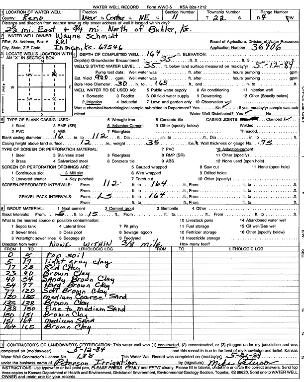
Specific Water Well Detail |
|
|
| Location Info | |||
| Owner: Schmidt, Wayne | Status: Constructed | ||
| Location: T22S, R4W, Sec. 11, NC NE | County: Reno | ||
| Directions: from Buhler: 2.5 mi E, .75 mi N | |||
| Latitude: 38.1575195 | Longitude: -97.7245809 | Datum NAD 27 | |
| Latitude: 38.1575294 | Longitude: -97.7249052 | Datum NAD 83 | |
| Longitude and latitude calculated by Survey from township-range-section-quarter calls. Only good to within the quarter call accuracy. | |||
| View well on interactive map | |||
| General Info | ||
| Well Depth: 164 ft. | Elevation: ft. | |
| Static Water Level: 35 ft. | Est. Yield: 900 gpm. | |
| Comp. Date: 12-May-1984 | Well Use: Irrigation | |
| DWR Applic. #: 36906 | Other ID: | |
| Links | |
| No Wizard information available. | |
| View info from WIMAS Water Right Data base... | |
| Driller Info | ||
| Driller: Peterson Irrigation, Inc. | License #: 138 | |
| Scanned Form | View scan |
|
Chemical Sample Submitted?: No
Water Well disinfected?: | ||
| Ground water encountered: 35 ft. , 0 ft. , 0 ft. | ||
| Pump test data: Well water was 0 ft after 0 hours pumping 0 gpm | ||
| Casing Info | ||
| Casing Type: ASBESTOS-CEMENT
Casing Joints: |
Diam: 16 in. to 112 ft
Diam: 0 in. to 0 ft Diam: 0 in. to 0 ft | |
| Casing height above land surface: in
Casing Weight: lbs/ft Wall thickness or gauge no.: | ||
| Screen and Perforation Info | ||
| Screen Type: ASBESTOS-CEMENT | Screen Openings: Mill slot | |
| Screen-perforated intervals | From: 112 ft to 164 ft
From: 0 ft to 0 ft From: 0 ft to 0 ft | |
| Gravel pack intervals | From: ft to ft | |
| Grout Info | ||
| Grout used: Cement grout | From: 5 to 15 ft
From: 0 to 0 ft From: 0 to 0 ft | |
| Source of Possible Contamination | ||
| Source: | ||
| Direction from well: | Distance: 0 ft | |
| Lithologic Log
(Log data entered by KGS.) | ||
| From: 0 ft. to 5 ft. | top soil | |
| From: 5 ft. to 17 ft. | light gray clay | |
| From: 17 ft. to 23 ft. | red clay | |
| From: 23 ft. to 40 ft. | brown clay | |
| From: 40 ft. to 54 ft. | sandy brown clay | |
| From: 54 ft. to 77 ft. | hard brown clay | |
| From: 77 ft. to 120 ft. | soft brown clay | |
| From: 120 ft. to 135 ft. | medium coarse sand | |
| From: 135 ft. to 138 ft. | brown clay | |
| From: 138 ft. to 150 ft. | fine to medium sand | |
| From: 150 ft. to 151 ft. | brown clay | |
| From: 151 ft. to 164 ft. | medium sand | |
| From: 164 ft. to 165 ft. | brown clay | |