|
|
|
Specific Water Well Detail |
|
|
| Location Info | |||
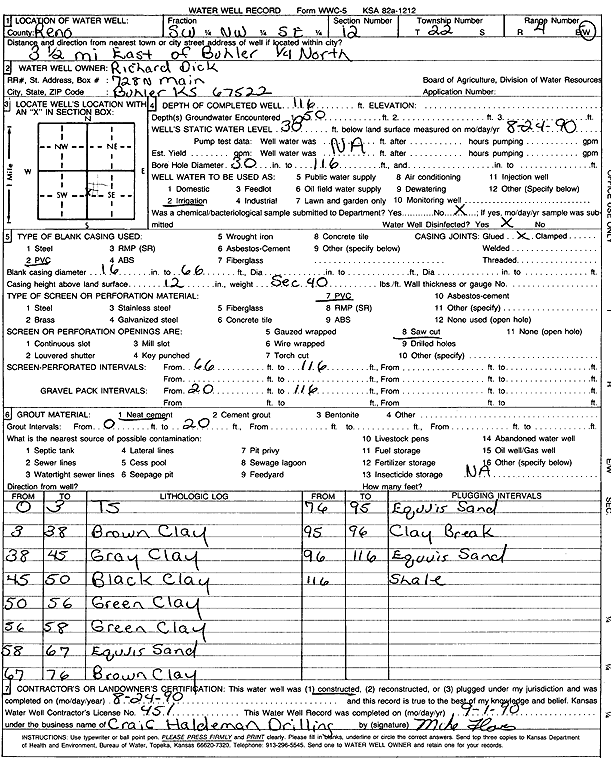
| Owner: Dick, Richard | Status: Constructed | ||
| Location: T22S, R4W, Sec. 12, SW NW SE | County: Reno | ||
| Directions: from Buhler: 3.5 mi E, .25 mi N | |||
| Latitude: 38.1493155 | Longitude: -97.7096603 | Datum NAD 27 | |
| Latitude: 38.1493255 | Longitude: -97.7099842 | Datum NAD 83 | |
| Longitude and latitude calculated by Survey from township-range-section-quarter calls. Only good to within the quarter call accuracy. | |||
| View well on interactive map | |||
| General Info | ||
| Well Depth: 116 ft. | Elevation: ft. | |
| Static Water Level: 38 ft. | Est. Yield: gpm. | |
| Comp. Date: 24-Aug-1990 | Well Use: Irrigation | |
| DWR Applic. #: | Other ID: | |
| Links | |
| No Wizard information available. | |
| View info from WIMAS Water Right Data base... | |
| Driller Info | ||
| Driller: Craig Haldeman Well Drilling & Pump Service | License #: 451 | |
| Scanned Form | View scan |
|
Chemical Sample Submitted?: No
Water Well disinfected?: | ||
| Ground water encountered: 50 ft. , 0 ft. , 0 ft. | ||
| Pump test data: Well water was 0 ft after 0 hours pumping 0 gpm | ||
| Casing Info | ||
| Casing Type: PVC
Casing Joints: |
Diam: 16 in. to 66 ft
Diam: 0 in. to 0 ft Diam: 0 in. to 0 ft | |
| Casing height above land surface: in
Casing Weight: lbs/ft Wall thickness or gauge no.: | ||
| Screen and Perforation Info | ||
| Screen Type: PVC | Screen Openings: Saw cut | |
| Screen-perforated intervals | From: 66 ft to 116 ft
From: 0 ft to 0 ft From: 0 ft to 0 ft | |
| Gravel pack intervals | From: ft to ft | |
| Grout Info | ||
| Grout used: Neat cement | From: 0 to 20 ft
From: 0 to 0 ft From: 0 to 0 ft | |
| Source of Possible Contamination | ||
| Source: OTHER | ||
| Direction from well: | Distance: 0 ft | |
| Lithologic Log
(Log data entered by KGS.) | ||
| From: 0 ft. to 3 ft. | top soil | |
| From: 3 ft. to 38 ft. | brown clay | |
| From: 38 ft. to 45 ft. | gray clay | |
| From: 45 ft. to 50 ft. | black clay | |
| From: 50 ft. to 56 ft. | green clay | |
| From: 56 ft. to 58 ft. | green clay | |
| From: 58 ft. to 67 ft. | Equus sand | |
| From: 67 ft. to 76 ft. | brown clay | |
| From: 76 ft. to 95 ft. | Equus sand | |
| From: 95 ft. to 96 ft. | clay | |
| From: 96 ft. to 116 ft. | Equus sand | |
| From: 116 ft. to ft. | shale | |