|
|
|
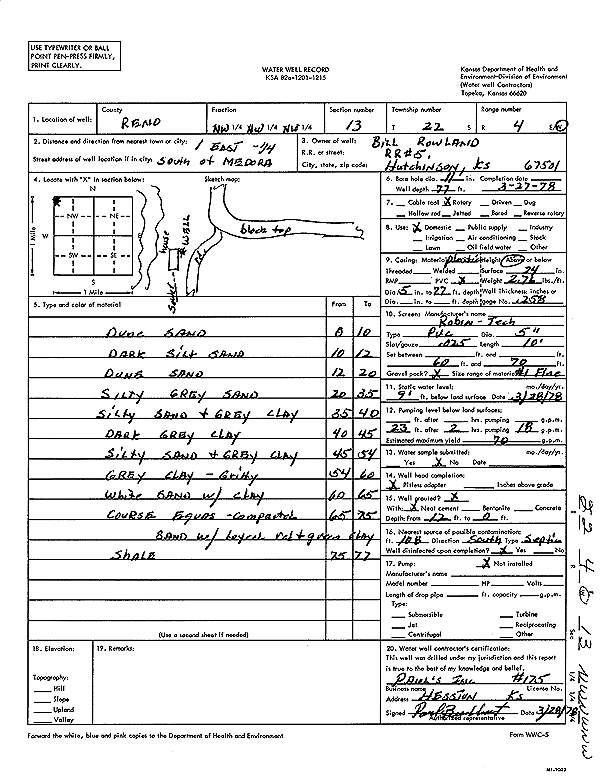
Specific Water Well Detail |
|
|
| Location Info | |||
| Owner: Rowland, Bill | Status: Constructed | ||
| Location: T22S, R4W, Sec. 13, NW NW NW | County: Reno | ||
| Directions: from Medora: 1 mi E, .25 mi S | |||
| Latitude: 38.1438401 | Longitude: -97.718913 | Datum NAD 27 | |
| Latitude: 38.1438501 | Longitude: -97.7192372 | Datum NAD 83 | |
| Longitude and latitude calculated by Survey from township-range-section-quarter calls. Only good to within the quarter call accuracy. | |||
| View well on interactive map | |||
| General Info | ||
| Well Depth: 77 ft. | Elevation: ft. | |
| Static Water Level: 9 ft. | Est. Yield: 70 gpm. | |
| Comp. Date: 27-Mar-1978 | Well Use: Domestic | |
| DWR Applic. #: | Other ID: | |
| Driller Info | ||
| Driller: Paul's Incorporated | License #: 175 | |
| Scanned Form | View scan |
|
Chemical Sample Submitted?: No
Water Well disinfected?: | ||
| Ground water encountered: 0 ft. , 0 ft. , 0 ft. | ||
| Pump test data: Well water was 0 ft after 0 hours pumping 0 gpm | ||
| Casing Info | ||
| Casing Type:
Casing Joints: |
Diam: 0 in. to 0 ft
Diam: 0 in. to 0 ft Diam: 0 in. to 0 ft | |
| Casing height above land surface: in
Casing Weight: lbs/ft Wall thickness or gauge no.: | ||
| Screen and Perforation Info | ||
| Screen Type: | Screen Openings: | |
| Screen-perforated intervals | From: 60 ft to 70 ft
From: 0 ft to 0 ft From: 0 ft to 0 ft | |
| Gravel pack intervals | From: ft to ft | |
| Grout Info | ||
| Grout used: | From: 0 to 0 ft
From: 0 to 0 ft From: 0 to 0 ft | |
| Source of Possible Contamination | ||
| Source: | ||
| Direction from well: | Distance: 0 ft | |
| Lithologic Log
(Log data entered by KGS.) | ||
| From: 0 ft. to 10 ft. | dune sand | |
| From: 10 ft. to 12 ft. | dark silt sand | |
| From: 12 ft. to 20 ft. | dune sand | |
| From: 20 ft. to 35 ft. | silty gray sand | |
| From: 35 ft. to 40 ft. | silty sand and gray clay | |
| From: 40 ft. to 45 ft. | dark gray clay | |
| From: 45 ft. to 54 ft. | silty sand and gray clay | |
| From: 54 ft. to 60 ft. | gray clay, gritty | |
| From: 60 ft. to 65 ft. | white sand with clay | |
| From: 65 ft. to 75 ft. | coarse Equus compacted sand with layers of red and green clay | |
| From: 75 ft. to 77 ft. | shale | |