|
|
|
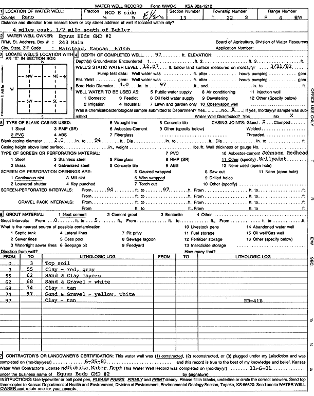
Specific Water Well Detail |
|
|
| Location Info | |||
| Owner: Equus Beds GMD 2 | Status: Constructed | ||
| Location: T22S, R4W, Sec. 13, C E2 | County: Reno | ||
| Directions: from Buhler: 4 mi E, .5 mi S | |||
| Latitude: 38.1375314 | Longitude: -97.7061939 | Datum NAD 27 | |
| Latitude: 38.1375415 | Longitude: -97.7065177 | Datum NAD 83 | |
| Longitude and latitude calculated by Survey from township-range-section-quarter calls. Only good to within the quarter call accuracy. | |||
| View well on interactive map | |||
| General Info | ||
| Well Depth: 97 ft. | Elevation: ft. | |
| Static Water Level: 12.07 ft. | Est. Yield: gpm. | |
| Comp. Date: 25-Jun-1981 | Well Use: Monitoring well/observation/piezometer | |
| DWR Applic. #: | Other ID: EB 41-B | |
| Driller Info | ||
| Driller: Wichita Water Dept. | License #: | |
| Scanned Form | View scan |
|
Chemical Sample Submitted?: No
Water Well disinfected?: | ||
| Ground water encountered: 0 ft. , 0 ft. , 0 ft. | ||
| Pump test data: Well water was 0 ft after 0 hours pumping 0 gpm | ||
| Casing Info | ||
| Casing Type: PVC
Casing Joints: |
Diam: 2 in. to 94 ft
Diam: 0 in. to 0 ft Diam: 0 in. to 0 ft | |
| Casing height above land surface: in
Casing Weight: lbs/ft Wall thickness or gauge no.: | ||
| Screen and Perforation Info | ||
| Screen Type: OTHER | Screen Openings: Wire wrapped | |
| Screen-perforated intervals | From: 94 ft to 97 ft
From: 0 ft to 0 ft From: 0 ft to 0 ft | |
| Gravel pack intervals | From: ft to ft | |
| Grout Info | ||
| Grout used: Neat cement | From: 0 to 5 ft
From: 0 to 0 ft From: 0 to 0 ft | |
| Source of Possible Contamination | ||
| Source: | ||
| Direction from well: | Distance: 0 ft | |
| Lithologic Log
(Log data entered by KGS.) | ||
| From: 0 ft. to 3 ft. | top soil | |
| From: 3 ft. to 55 ft. | clay, red, gray | |
| From: 55 ft. to 62 ft. | sand and clay layers | |
| From: 62 ft. to 68 ft. | sand and gravel, white | |
| From: 68 ft. to 74 ft. | clay, tan | |
| From: 74 ft. to 97 ft. | sand and gravel, yellow, white | |
| From: 97 ft. to ft. | clay, tan | |