|
|
|
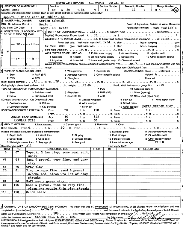
Specific Water Well Detail |
|
|
| Location Info | |||
| Owner: Schmidt, Gordon | Status: Constructed | ||
| Location: T22S, R4W, Sec. 14, SW SW SE | County: Reno | ||
| Directions: from Buhler: 2 mi E | |||
| Latitude: 38.1311406 | Longitude: -97.7282313 | Datum NAD 27 | |
| Latitude: 38.1311509 | Longitude: -97.7285557 | Datum NAD 83 | |
| Longitude and latitude calculated by Survey from township-range-section-quarter calls. Only good to within the quarter call accuracy. | |||
| View well on interactive map | |||
| General Info | ||
| Well Depth: 118 ft. | Elevation: ft. | |
| Static Water Level: 33 ft. | Est. Yield: 800 gpm. | |
| Comp. Date: 29-Feb-1984 | Well Use: Irrigation | |
| DWR Applic. #: | Other ID: | |
| Links | |
| No Wizard information available. | |
| View info from WIMAS Water Right Data base... | |
| Driller Info | ||
| Driller: Clarke Well and Equipment, Inc. | License #: 185 | |
| Scanned Form | View scan |
|
Chemical Sample Submitted?: No
Water Well disinfected?: | ||
| Ground water encountered: 33 ft. , 0 ft. , 0 ft. | ||
| Pump test data: Well water was 0 ft after 0 hours pumping 0 gpm | ||
| Casing Info | ||
| Casing Type: Steel
Casing Joints: |
Diam: 16 in. to 70 ft
Diam: 0 in. to 0 ft Diam: 0 in. to 0 ft | |
| Casing height above land surface: in
Casing Weight: lbs/ft Wall thickness or gauge no.: | ||
| Screen and Perforation Info | ||
| Screen Type: Steel | Screen Openings: OTHER | |
| Screen-perforated intervals | From: 70 ft to 118 ft
From: 0 ft to 0 ft From: 0 ft to 0 ft | |
| Gravel pack intervals | From: ft to ft | |
| Grout Info | ||
| Grout used: Neat cement | From: 0 to 10 ft
From: 0 to 0 ft From: 0 to 0 ft | |
| Source of Possible Contamination | ||
| Source: OTHER | ||
| Direction from well: | Distance: 0 ft | |
| Lithologic Log
(Log data entered by KGS.) | ||
| From: 0 ft. to 67 ft. | top soil and tan clay, some real soft, sandy | |
| From: 67 ft. to 68 ft. | sand and gravel, very fine, and gray clay | |
| From: 68 ft. to 70 ft. | gray clay | |
| From: 70 ft. to 81 ft. | fine to very fine sand and gravel with some medium, clean, with lots of clay streaks | |
| From: 81 ft. to 86 ft. | soft sandy green clay | |
| From: 86 ft. to 116 ft. | fine to very fine sand and gravel, clean, with a couple of thin clay streaks | |
| From: 116 ft. to 118 ft. | green shale | |