|
|
|
Specific Water Well Detail |
|
|
| Location Info | |||
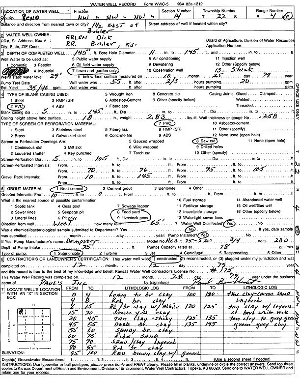
| Owner: Dick, Arlen | Status: Constructed | ||
| Location: T22S, R4W, Sec. 14, NW NW NW | County: Reno | ||
| Directions: from Buhler: 1.5 mi E | |||
| Latitude: 38.1439601 | Longitude: -97.7374734 | Datum NAD 27 | |
| Latitude: 38.1439701 | Longitude: -97.7377982 | Datum NAD 83 | |
| Longitude and latitude calculated by Survey from township-range-section-quarter calls. Only good to within the quarter call accuracy. | |||
| View well on interactive map | |||
| General Info | ||
| Well Depth: 145 ft. | Elevation: ft. | |
| Static Water Level: 29 ft. | Est. Yield: 40 gpm. | |
| Comp. Date: 12-Dec-1979 | Well Use: Domestic, Lawn and Garden | |
| DWR Applic. #: | Other ID: | |
| Driller Info | ||
| Driller: Paul's Incorporated | License #: 175 | |
| Scanned Form | View scan |
|
Chemical Sample Submitted?: No
Water Well disinfected?: | ||
| Ground water encountered: 0 ft. , 0 ft. , 0 ft. | ||
| Pump test data: Well water was 0 ft after 0 hours pumping 0 gpm | ||
| Casing Info | ||
| Casing Type:
Casing Joints: |
Diam: 0 in. to 0 ft
Diam: 0 in. to 0 ft Diam: 0 in. to 0 ft | |
| Casing height above land surface: in
Casing Weight: lbs/ft Wall thickness or gauge no.: | ||
| Screen and Perforation Info | ||
| Screen Type: | Screen Openings: | |
| Screen-perforated intervals | From: 70 ft to 76 ft
From: 0 ft to 0 ft From: 0 ft to 0 ft | |
| Gravel pack intervals | From: ft to ft | |
| Grout Info | ||
| Grout used: | From: 0 to 0 ft
From: 0 to 0 ft From: 0 to 0 ft | |
| Source of Possible Contamination | ||
| Source: | ||
| Direction from well: | Distance: 0 ft | |
| Lithologic Log
(Log data entered by KGS.) | ||
| From: 0 ft. to 4 ft. | loam to brown clay | |
| From: 4 ft. to 8 ft. | red brown clay | |
| From: 8 ft. to 15 ft. | red-brown clay with alkali | |
| From: 15 ft. to 20 ft. | brown yellow clay | |
| From: 20 ft. to 45 ft. | tan clay, sticky | |
| From: 45 ft. to 55 ft. | dark brown clay | |
| From: 55 ft. to 60 ft. | sandy brown clay | |
| From: 60 ft. to 75 ft. | fine sand | |
| From: 75 ft. to 90 ft. | sand and clay, layered | |
| From: 90 ft. to 95 ft. | red brown clay | |
| From: 95 ft. to 100 ft. | red brown clay with gravel | |
| From: 100 ft. to 120 ft. | thin clay and coarse sand, layered | |
| From: 120 ft. to 125 ft. | tan clay with layers of hard white rock | |
| From: 125 ft. to 135 ft. | clay, tan to gray green | |
| From: 135 ft. to 145 ft. | green gray clay | |