|
|
|
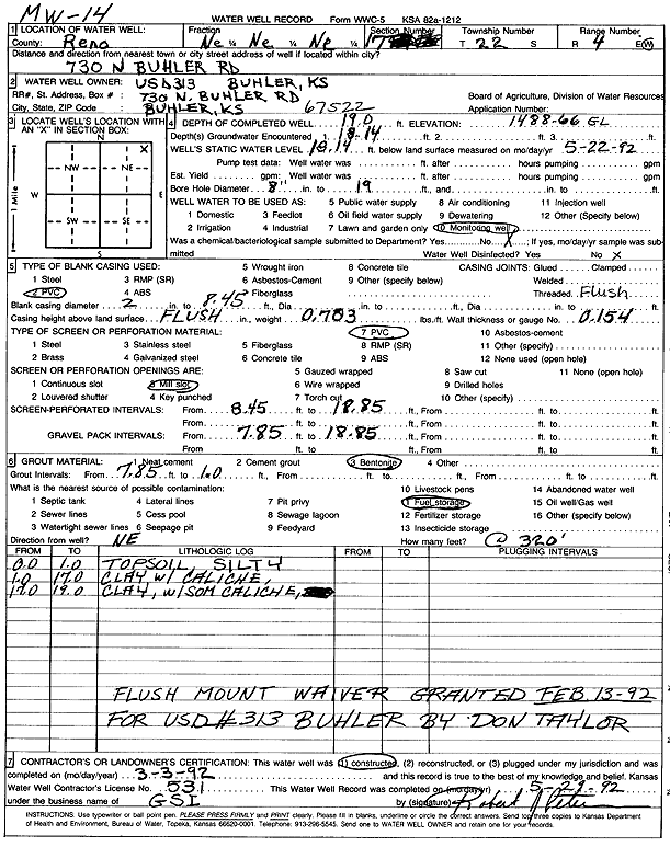
Specific Water Well Detail |
|
|
| Location Info | |||
| Owner: USD 313 | Status: Constructed | ||
| Location: T22S, R4W, Sec. 17, NE NE NE | County: Reno | ||
| Directions: 730 N Buhler Rd, Buhler | |||
| Latitude: 38.1438475 | Longitude: -97.7767611 | Datum NAD 27 | |
| Latitude: 38.1438577 | Longitude: -97.7770869 | Datum NAD 83 | |
| Longitude and latitude calculated by Survey from township-range-section-quarter calls. Only good to within the quarter call accuracy. | |||
| View well on interactive map | |||
| General Info | ||
| Well Depth: 19 ft. | Elevation: 1488.66 ft. | |
| Static Water Level: 18.14 ft. | Est. Yield: gpm. | |
| Comp. Date: 03-Mar-1992 | Well Use: Monitoring well/observation/piezometer | |
| DWR Applic. #: | Other ID: MW 14 | |
| Driller Info | ||
| Driller: Geotechnical Services, Inc. | License #: 531 | |
| Scanned Form | View scan |
|
Chemical Sample Submitted?: No
Water Well disinfected?: | ||
| Ground water encountered: 18 ft. , 0 ft. , 0 ft. | ||
| Pump test data: Well water was 0 ft after 0 hours pumping 0 gpm | ||
| Casing Info | ||
| Casing Type: PVC
Casing Joints: |
Diam: 2 in. to 8 ft
Diam: 0 in. to 0 ft Diam: 0 in. to 0 ft | |
| Casing height above land surface: in
Casing Weight: lbs/ft Wall thickness or gauge no.: | ||
| Screen and Perforation Info | ||
| Screen Type: PVC | Screen Openings: Mill slot | |
| Screen-perforated intervals | From: 8 ft to 18 ft
From: 0 ft to 0 ft From: 0 ft to 0 ft | |
| Gravel pack intervals | From: ft to ft | |
| Grout Info | ||
| Grout used: Bentonite | From: 1 to 7 ft
From: 0 to 0 ft From: 0 to 0 ft | |
| Source of Possible Contamination | ||
| Source: Fuel storage | ||
| Direction from well: | Distance: 0 ft | |
| Lithologic Log
(Log data entered by KGS.) | ||
| From: 0 ft. to 1 ft. | silty top soil | |
| From: 1 ft. to 17 ft. | clay with caliche | |
| From: 17 ft. to 19 ft. | clay with some caliche | |