|
|
|
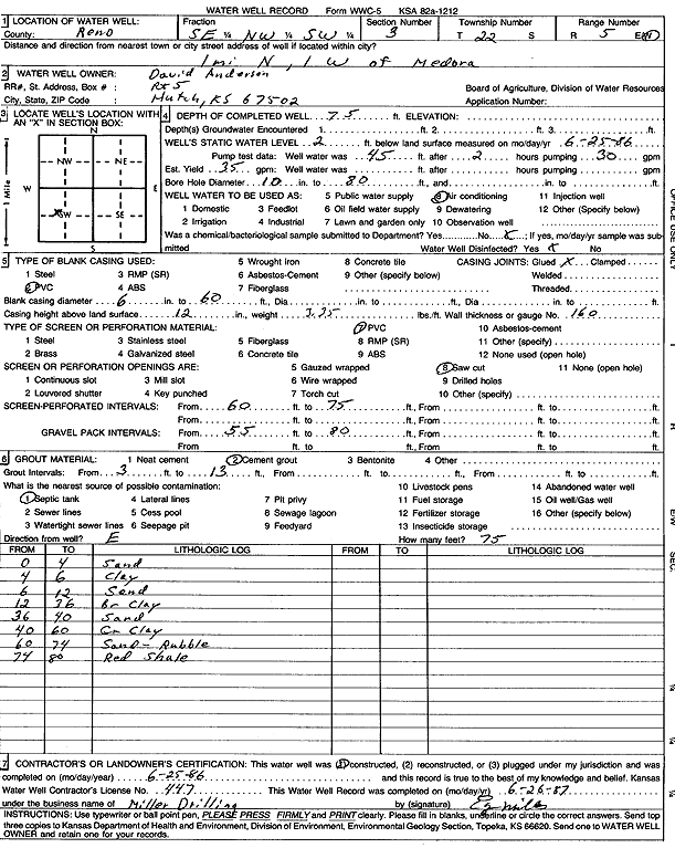
Specific Water Well Detail |
|
|
| Location Info | |||
| Owner: Anderson, David | Status: Constructed | ||
| Location: T22S, R5W, Sec. 3, SE NW SW | County: Reno | ||
| Directions: from Medora: 1 mi N, 1 mi W | |||
| Latitude: 38.1637977 | Longitude: -97.8632775 | Datum NAD 27 | |
| Latitude: 38.1638079 | Longitude: -97.8636052 | Datum NAD 83 | |
| Longitude and latitude calculated by Survey from township-range-section-quarter calls. Only good to within the quarter call accuracy. | |||
| View well on interactive map | |||
| General Info | ||
| Well Depth: 75 ft. | Elevation: ft. | |
| Static Water Level: 2 ft. | Est. Yield: 35 gpm. | |
| Comp. Date: 25-Jun-1986 | Well Use: Air Conditioning | |
| DWR Applic. #: | Other ID: | |
| Driller Info | ||
| Driller: Miller Drilling | License #: 447 | |
| Scanned Form | View scan |
|
Chemical Sample Submitted?: No
Water Well disinfected?: | ||
| Ground water encountered: 0 ft. , 0 ft. , 0 ft. | ||
| Pump test data: Well water was 45 ft after 2 hours pumping 30 gpm | ||
| Casing Info | ||
| Casing Type: PVC
Casing Joints: |
Diam: 6 in. to 60 ft
Diam: 0 in. to 0 ft Diam: 0 in. to 0 ft | |
| Casing height above land surface: in
Casing Weight: lbs/ft Wall thickness or gauge no.: | ||
| Screen and Perforation Info | ||
| Screen Type: PVC | Screen Openings: Saw cut | |
| Screen-perforated intervals | From: 60 ft to 75 ft
From: 0 ft to 0 ft From: 0 ft to 0 ft | |
| Gravel pack intervals | From: ft to ft | |
| Grout Info | ||
| Grout used: Cement grout | From: 3 to 13 ft
From: 0 to 0 ft From: 0 to 0 ft | |
| Source of Possible Contamination | ||
| Source: Septic Tank | ||
| Direction from well: | Distance: 0 ft | |
| Lithologic Log
(Log data entered by KGS.) | ||
| From: 0 ft. to 4 ft. | sand | |
| From: 4 ft. to 6 ft. | clay | |
| From: 6 ft. to 12 ft. | sand | |
| From: 12 ft. to 36 ft. | brown clay | |
| From: 36 ft. to 40 ft. | sand | |
| From: 40 ft. to 60 ft. | gray clay | |
| From: 60 ft. to 74 ft. | sand and rubble | |
| From: 74 ft. to 80 ft. | red shale | |