|
|
|
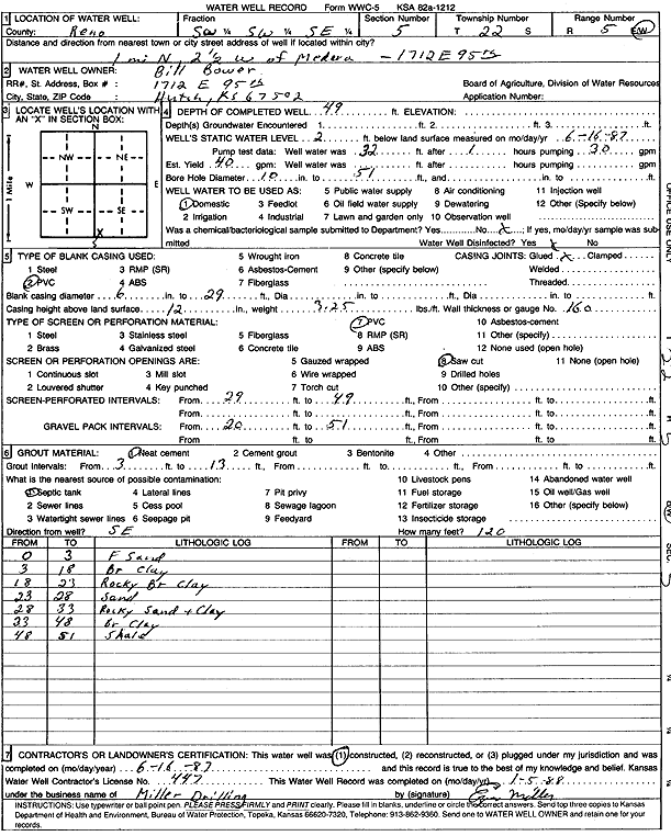
Specific Water Well Detail |
|
|
| Location Info | |||
| Owner: Bower, Bill | Status: Constructed | ||
| Location: T22S, R5W, Sec. 5, SW SW SE | County: Reno | ||
| Directions: 1712 E 95, Hutchinson - from Medora: 1 mi N, 2.5 mi W | |||
| Latitude: 38.1601792 | Longitude: -97.8932054 | Datum NAD 27 | |
| Latitude: 38.1601896 | Longitude: -97.893534 | Datum NAD 83 | |
| Longitude and latitude calculated by Survey from township-range-section-quarter calls. Only good to within the quarter call accuracy. | |||
| View well on interactive map | |||
| General Info | ||
| Well Depth: 49 ft. | Elevation: ft. | |
| Static Water Level: 2 ft. | Est. Yield: 40 gpm. | |
| Comp. Date: 16-Jun-1987 | Well Use: Domestic | |
| DWR Applic. #: | Other ID: | |
| Driller Info | ||
| Driller: Miller Drilling | License #: 447 | |
| Scanned Form | View scan |
|
Chemical Sample Submitted?: No
Water Well disinfected?: | ||
| Ground water encountered: 0 ft. , 0 ft. , 0 ft. | ||
| Pump test data: Well water was 32 ft after 1 hours pumping 30 gpm | ||
| Casing Info | ||
| Casing Type: PVC
Casing Joints: |
Diam: 6 in. to 29 ft
Diam: 0 in. to 0 ft Diam: 0 in. to 0 ft | |
| Casing height above land surface: in
Casing Weight: lbs/ft Wall thickness or gauge no.: | ||
| Screen and Perforation Info | ||
| Screen Type: PVC | Screen Openings: Saw cut | |
| Screen-perforated intervals | From: 29 ft to 49 ft
From: 0 ft to 0 ft From: 0 ft to 0 ft | |
| Gravel pack intervals | From: ft to ft | |
| Grout Info | ||
| Grout used: Neat cement | From: 3 to 13 ft
From: 0 to 0 ft From: 0 to 0 ft | |
| Source of Possible Contamination | ||
| Source: Septic Tank | ||
| Direction from well: | Distance: 0 ft | |
| Lithologic Log
(Log data entered by KGS.) | ||
| From: 0 ft. to 3 ft. | fine sand | |
| From: 3 ft. to 18 ft. | brown clay | |
| From: 18 ft. to 23 ft. | rocky brown clay | |
| From: 23 ft. to 28 ft. | sand | |
| From: 28 ft. to 33 ft. | rocky sand and clay | |
| From: 33 ft. to 48 ft. | brown clay | |
| From: 48 ft. to 51 ft. | shale | |