|
|
|
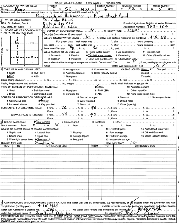
Specific Water Well Detail |
|
|
| Location Info | |||
| Owner: Blank, John | Status: Plugged | ||
| Location: T22S, R5W, Sec. 6, C SE NW | County: Reno | ||
| Directions: from Hutchinson: 8 mi N on Plum St Rd | |||
| Latitude: 38.1682408 | Longitude: -97.9149818 | Datum NAD 27 | |
| Latitude: 38.1682512 | Longitude: -97.9153108 | Datum NAD 83 | |
| Longitude and latitude calculated by Survey from township-range-section-quarter calls. Only good to within the quarter call accuracy. | |||
| View well on interactive map | |||
| General Info | ||
| Well Depth: 90 ft. | Elevation: 1584 ft. | |
| Static Water Level: 30 ft. | Est. Yield: gpm. | |
| Comp. Date: 15-Apr-1983 | Well Use: Oil Field Water Supply | |
| DWR Applic. #: T83-124 | Other ID: | |
| Driller Info | ||
| Driller: Heartland Drilling, Inc. | License #: | |
| Scanned Form | View scan |
| Casing Info | ||
|
Casing Type: PVC
Diam: 0 in. Casing height above land surface: in | ||
| Grout Info | ||
| Grout used: Neat cement | From: 0 to 15 ft
From: 0 to 0 ft From: 0 to 0 ft | |
| Source of Possible Contamination | ||
| Source: Seepage pit | ||
| Direction from well: | Distance: 0 ft | |