|
|
|
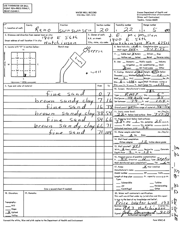
Specific Water Well Detail |
|
|
| Location Info | |||
| Owner: McMullen, J.E. | Status: Constructed | ||
| Location: T22S, R5W, Sec. 20, SW SW SE | County: Reno | ||
| Directions: 1800 East 56th, Hutchinson | |||
| Latitude: 38.1165684 | Longitude: -97.893056 | Datum NAD 27 | |
| Latitude: 38.116579 | Longitude: -97.8933848 | Datum NAD 83 | |
| Longitude and latitude calculated by Survey from township-range-section-quarter calls. Only good to within the quarter call accuracy. | |||
| View well on interactive map | |||
| General Info | ||
| Well Depth: 104 ft. | Elevation: ft. | |
| Static Water Level: 22 ft. | Est. Yield: 30 gpm. | |
| Comp. Date: 17-Jul-1975 | Well Use: Domestic, Lawn and Garden | |
| DWR Applic. #: | Other ID: | |
| Driller Info | ||
| Driller: Price Water Well Service | License #: 193 | |
| Scanned Form | View scan |
|
Chemical Sample Submitted?: No
Water Well disinfected?: | ||
| Ground water encountered: 0 ft. , 0 ft. , 0 ft. | ||
| Pump test data: Well water was 0 ft after 0 hours pumping 0 gpm | ||
| Casing Info | ||
| Casing Type:
Casing Joints: |
Diam: 0 in. to 0 ft
Diam: 0 in. to 0 ft Diam: 0 in. to 0 ft | |
| Casing height above land surface: in
Casing Weight: lbs/ft Wall thickness or gauge no.: | ||
| Screen and Perforation Info | ||
| Screen Type: | Screen Openings: | |
| Screen-perforated intervals | From: 79 ft to 104 ft
From: 0 ft to 0 ft From: 0 ft to 0 ft | |
| Gravel pack intervals | From: ft to ft | |
| Grout Info | ||
| Grout used: | From: 0 to 0 ft
From: 0 to 0 ft From: 0 to 0 ft | |
| Source of Possible Contamination | ||
| Source: | ||
| Direction from well: | Distance: 0 ft | |
| Lithologic Log
(Log data entered by KGS.) | ||
| From: 0 ft. to 7 ft. | fine sand | |
| From: 7 ft. to 16 ft. | brown sandy clay | |
| From: 16 ft. to 38 ft. | fine sand | |
| From: 38 ft. to 54 ft. | brown sandy clay | |
| From: 54 ft. to 66 ft. | fine sand | |
| From: 66 ft. to 71 ft. | brown sandy clay | |
| From: 71 ft. to 104 ft. | fine sand | |