|
|
|
Specific Water Well Detail |
|
|
| Location Info | |||
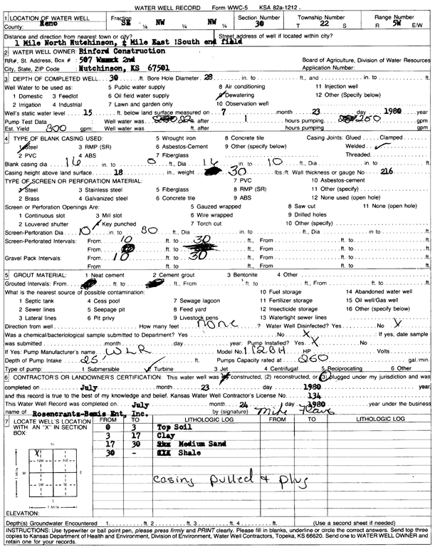
| Owner: Binford Construction | Status: Plugged | ||
| Location: T22S, R5W, Sec. 30, SE NW NW | County: Reno | ||
| Directions: from Hutchinson: 1 mi N, .25 mi E, 1 mi S end field | |||
| Latitude: 38.1128335 | Longitude: -97.9183029 | Datum NAD 27 | |
| Latitude: 38.1128442 | Longitude: -97.9186324 | Datum NAD 83 | |
| Longitude and latitude calculated by Survey from township-range-section-quarter calls. Only good to within the quarter call accuracy. | |||
| View well on interactive map | |||
| General Info | ||
| Well Depth: 30 ft. | Elevation: ft. | |
| Static Water Level: 15 ft. | Est. Yield: 300 gpm. | |
| Comp. Date: 23-Jul-1980 | Well Use: Dewatering | |
| DWR Applic. #: | Other ID: | |
| Driller Info | ||
| Driller: Rosencrantz-Bemis Enterprises, Inc. | License #: 134 | |
| Scanned Form | View scan |
| Casing Info | ||
|
Casing Type:
Diam: 0 in. Casing height above land surface: in | ||
| Grout Info | ||
| Grout used: | From: 0 to 0 ft
From: 0 to 0 ft From: 0 to 0 ft | |
| Source of Possible Contamination | ||
| Source: | ||
| Direction from well: | Distance: 0 ft | |
| Lithologic Log
(Log data entered by KGS.) | ||
| From: 0 ft. to 3 ft. | top soil | |
| From: 3 ft. to 17 ft. | clay | |
| From: 17 ft. to 30 ft. | medium sand | |
| From: 30 ft. to ft. | shale | |