|
|
|
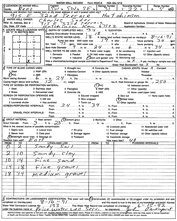
Specific Water Well Detail |
|
|
| Location Info | |||
| Owner: Sader, Charles | Status: Constructed | ||
| Location: T22S, R5W, Sec. 31, SW SW SE | County: Reno | ||
| Directions: 915 E 32nd Terrace, Hutchinson | |||
| Latitude: 38.0900425 | Longitude: -97.9107566 | Datum NAD 27 | |
| Latitude: 38.090055 | Longitude: -97.911089 | Datum NAD 83 | |
| Longitude and latitude from GPS measurements. | |||
| GPS Latitude: 38.090055 | GPS Longitude: -97.911089 | Datum WGS84 | |
| View well on interactive map | |||
| General Info | ||
| Well Depth: 34 ft. | Elevation: ft. | |
| Static Water Level: 18 ft. | Est. Yield: 75 gpm. | |
| Comp. Date: 16-Aug-1991 | Well Use: Domestic, Lawn and Garden | |
| DWR Applic. #: | Other ID: | |
| Driller Info | ||
| Driller: Price Water Well Service | License #: 193 | |
| Scanned Form | View scan |
|
Chemical Sample Submitted?: No
Water Well disinfected?: | ||
| Ground water encountered: 18 ft. , 0 ft. , 0 ft. | ||
| Pump test data: Well water was 19 ft after 1 hours pumping 30 gpm | ||
| Casing Info | ||
| Casing Type: PVC
Casing Joints: |
Diam: 6 in. to 24 ft
Diam: 0 in. to 0 ft Diam: 0 in. to 0 ft | |
| Casing height above land surface: in
Casing Weight: lbs/ft Wall thickness or gauge no.: | ||
| Screen and Perforation Info | ||
| Screen Type: PVC | Screen Openings: Drilled holes | |
| Screen-perforated intervals | From: 24 ft to 34 ft
From: 0 ft to 0 ft From: 0 ft to 0 ft | |
| Gravel pack intervals | From: ft to ft | |
| Grout Info | ||
| Grout used: Cement grout | From: 3 to 23 ft
From: 0 to 0 ft From: 0 to 0 ft | |
| Source of Possible Contamination | ||
| Source: Watertight sewer lines | ||
| Direction from well: | Distance: 0 ft | |
| Lithologic Log
(Log data entered by KGS.) | ||
| From: 0 ft. to 2 ft. | sandy soil | |
| From: 2 ft. to 10 ft. | sandy clay | |
| From: 10 ft. to 14 ft. | fine sand | |
| From: 14 ft. to 18 ft. | fine gravel | |
| From: 18 ft. to 34 ft. | medium gravel | |