|
|
|
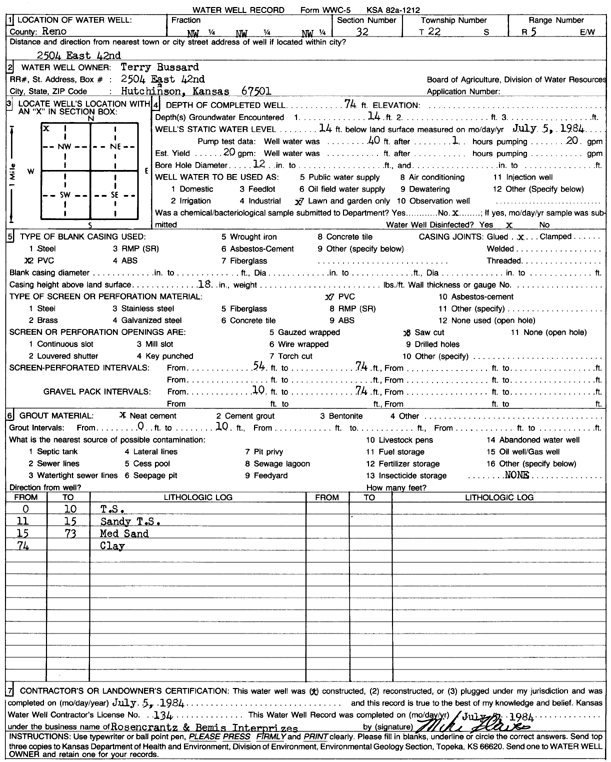
Specific Water Well Detail |
|
|
| Location Info | |||
| Owner: Bussard, Terry | Status: Constructed | ||
| Location: T22S, R5W, Sec. 32, NW NW NW | County: Reno | ||
| Directions: 2504 E 42nd, Hutchinson | |||
| Latitude: 38.1001236 | Longitude: -97.9022953 | Datum NAD 27 | |
| Latitude: 38.1001346 | Longitude: -97.9026244 | Datum NAD 83 | |
| Longitude and latitude calculated by Survey from township-range-section-quarter calls. Only good to within the quarter call accuracy. | |||
| View well on interactive map | |||
| General Info | ||
| Well Depth: 74 ft. | Elevation: ft. | |
| Static Water Level: 14 ft. | Est. Yield: 20 gpm. | |
| Comp. Date: 05-Jul-1984 | Well Use: Domestic, Lawn and Garden | |
| DWR Applic. #: | Other ID: | |
| Driller Info | ||
| Driller: Rosencrantz-Bemis Enterprises, Inc. | License #: 134 | |
| Scanned Form | View scan |
|
Chemical Sample Submitted?: No
Water Well disinfected?: | ||
| Ground water encountered: 14 ft. , 0 ft. , 0 ft. | ||
| Pump test data: Well water was 40 ft after 1 hours pumping 20 gpm | ||
| Casing Info | ||
| Casing Type: PVC
Casing Joints: |
Diam: 0 in. to 0 ft
Diam: 0 in. to 0 ft Diam: 0 in. to 0 ft | |
| Casing height above land surface: in
Casing Weight: lbs/ft Wall thickness or gauge no.: | ||
| Screen and Perforation Info | ||
| Screen Type: | Screen Openings: Torch cut | |
| Screen-perforated intervals | From: 854 ft to 74 ft
From: 0 ft to 0 ft From: 0 ft to 0 ft | |
| Gravel pack intervals | From: ft to ft | |
| Grout Info | ||
| Grout used: Neat cement | From: 0 to 10 ft
From: 0 to 0 ft From: 0 to 0 ft | |
| Source of Possible Contamination | ||
| Source: OTHER | ||
| Direction from well: | Distance: 0 ft | |
| Lithologic Log
(Log data entered by KGS.) | ||
| From: 0 ft. to 10 ft. | top soil | |
| From: 10 ft. to 15 ft. | sandy top soil | |
| From: 15 ft. to 73 ft. | medium sand | |
| From: 73 ft. to ft. | clay | |