|
|
|
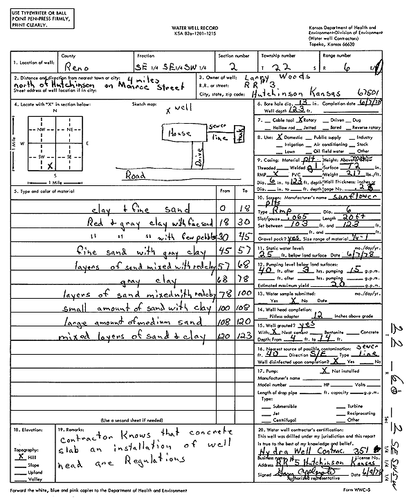
Specific Water Well Detail |
|
|
| Location Info | |||
| Owner: Woods, Larry | Status: Constructed | ||
| Location: T22S, R6W, Sec. 2, SE SE SW | County: Reno | ||
| Directions: from Hutchinson: 4 mi N on Monroe St | |||
| Latitude: 38.1599366 | Longitude: -97.9506244 | Datum NAD 27 | |
| Latitude: 38.1599472 | Longitude: -97.9509543 | Datum NAD 83 | |
| Longitude and latitude calculated by Survey from township-range-section-quarter calls. Only good to within the quarter call accuracy. | |||
| View well on interactive map | |||
| General Info | ||
| Well Depth: 123 ft. | Elevation: ft. | |
| Static Water Level: 25 ft. | Est. Yield: 20 gpm. | |
| Comp. Date: 07-Jun-1978 | Well Use: Domestic | |
| DWR Applic. #: | Other ID: | |
| Driller Info | ||
| Driller: Hydra Well Contractors | License #: 351 | |
| Scanned Form | View scan |
|
Chemical Sample Submitted?: No
Water Well disinfected?: | ||
| Ground water encountered: 0 ft. , 0 ft. , 0 ft. | ||
| Pump test data: Well water was 0 ft after 0 hours pumping 0 gpm | ||
| Casing Info | ||
| Casing Type:
Casing Joints: |
Diam: 0 in. to 0 ft
Diam: 0 in. to 0 ft Diam: 0 in. to 0 ft | |
| Casing height above land surface: in
Casing Weight: lbs/ft Wall thickness or gauge no.: | ||
| Screen and Perforation Info | ||
| Screen Type: | Screen Openings: | |
| Screen-perforated intervals | From: 103 ft to 123 ft
From: 0 ft to 0 ft From: 0 ft to 0 ft | |
| Gravel pack intervals | From: ft to ft | |
| Grout Info | ||
| Grout used: | From: 0 to 0 ft
From: 0 to 0 ft From: 0 to 0 ft | |
| Source of Possible Contamination | ||
| Source: | ||
| Direction from well: | Distance: 0 ft | |
| Lithologic Log
(Log data entered by KGS.) | ||
| From: 0 ft. to 18 ft. | clay and fine sand | |
| From: 18 ft. to 30 ft. | red and gray clay with fine sand | |
| From: 30 ft. to 45 ft. | red and gray clay with few pebbles | |
| From: 45 ft. to 57 ft. | fine sand with gray clay | |
| From: 57 ft. to 68 ft. | layers of sand mixed with red clay | |
| From: 68 ft. to 78 ft. | gray clay | |
| From: 78 ft. to 100 ft. | layers of sand mixed with red clay | |
| From: 100 ft. to 108 ft. | small amount of sand with clay | |
| From: 108 ft. to 120 ft. | large amount of medium sand | |
| From: 120 ft. to 123 ft. | mixed layers of sand and clay | |